
Please make your buying decision based on the part number not the image. Images are used for illustration only and may not be accurate.
+'&media='+encodeURIComponent('https://images.builderdepot.com/storeimg/3221.webp)+'&description='+encodeURIComponent(':prodname'))
Specifications
| Model No.: | 010-C1018-20 |
| Alternate Model Numbers: | 35811 010C101820 |
| UPC: | 753759095789 |
| Ship Weight (lbs): | 0.1 |
| SpectrumSuperStore SKU: | 2985189 (62) |
| Manufacturer: |
Garmin Please click on the manufacturer's name or logo to preview all products |
| Related Items: |
Garmin BlueChart g3 HD - HXUS604x - US All & Canadian West - microSD/SD / Each
Buy from SpectrumSuperStore
|
Retail: $219.99
Your Price
$219.98
Save: $0.01 that is over 0% off
|
Item Description
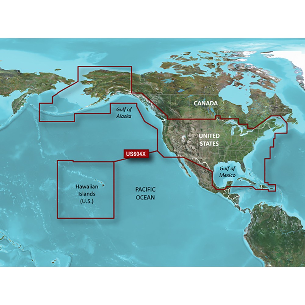
BlueChart® g3 HD - HXUS604x - US All & Canadian West - microSD™/SD™
Coverage
Provides detailed coastal coverage of the U.S., including the East Coast from Key West, FL, to the Canadian border, and the West Coast from Puget Sound to the Mexican border; Alaska; Hawaii and major inland rivers; the U.S. Gulf Coast to the Mexican border and the Mexican Gulf Coast to the Yucatan. Canadian coverage includes the entire St. Lawrence Seaway, Nova Scotia and New Brunswick. The Great Lakes are covered in their entirety as are the Lake of the Woods. Coverage includes Prince Edward Island, Anticosti Island, Vancouver Island, including the Inside and Outside Passages, the Aleutian and Channel Islands, the Bahamas, the Turks and Caicos Islands, Cozumel, Cuba, Hispaniola, Puerto Rico and the U.S. Virgin Islands.
Unparalleled Coastal Chart Coverage
- Provides industry-leading coverage, clarity and detail with updated coastal charts that feature integrated Garmin and Navionics® data
- Auto Guidance¹ technology calculates a route using your desired depth and overhead clearance and provides a suggested path to follow
- Includes Depth Range Shading for up to 10 depth ranges, enabling you to view your target depth at a glance
- Up to 1’ contours provide a more accurate depiction of the bottom structure for improved fishing charts and navigation in swamps, canals and marinas
- NOAA raster cartography² is available as a free downloadable feature via the ActiveCaptain® app
BlueChart g3 coastal charts provide industry-leading coverage, clarity and detail with integrated Garmin and Navionics data. Also included is Auto Guidance¹ technology, which uses your desired depth and overhead clearance to calculate routes and provide a suggested path to follow — overlaid onto your chart. NOAA raster cartography is also available as a free downloadable feature via the ActiveCaptain app. It gives your chartplotter paper chartlike views of NOAA-surveyed areas in which individual points of interest are labeled with corresponding longitude and latitude information. Worldwide coverage is available by regions as accessory cards or via download; each region is sold separately.
Auto Guidance Technology
The Auto Guidance feature¹ calculates a suggested route using your desired depth and overhead clearance.
Depth Range Shading
This feature displays high-resolution Depth Range Shading for up to 10 depth ranges so you can view your designated target depth.
Detailed Contours
BlueChart g3 features up to 1’ contours, which provide a more accurate depiction of the bottom structure for improved fishing charts and navigation in swamps, canals and marinas.
Shallow Water Shading
To aid in navigation, Shallow Water Shading allows map shading at a user-defined depth to give a clear picture of shallow waters to avoid.
NOAA Raster Cartography
This feature gives your chartplotter paper chartlike views of NOAA-surveyed areas in which points of interest are labeled with corresponding longitude and latitude information.
¹Auto Guidance is for planning purposes only and does not replace safe navigation operations
²Raster cartography cannot be viewed on echoMAP CHIRP and ECHOMAP Plus combos but can be viewed on mobile devices via the ActiveCaptain mobile app .
 WARNING: This product can expose you to chemicals which are known to the State of California to cause cancer, birth defects or other reproductive harm. For more information go to P65Warnings.ca.gov.
This product ships in approximately 2 days
Tools
| Estimate Shipping: | ||
| We can notify you when we get stock: |
Please enter your email address and the quantity you need below if you want us to notify you when we get stock for this item. Our buyers will get your email and work hard to get this item in stock.
|
|
| We can notify you when the price drops: |
Please enter your email address and your desired price for this item. We will email you when the price of this item changes to match your desired price.
|
|
Protect Your Investment - Purchase an Extended Warranty
|
|
|
|
Copyright © 1999-2024 BuilderDepot, Inc. Site Designed and Maintained by Inline Internet Systems, Inc. |