
Browse In:
Shop by Brand: Navionics
Sort by

Navionics NASA004L - Mexico, Caribbean to Brazil - Navionics+
Navionics NASA004L - Mexico, Caribbean to Brazil - Navionics+
Online
$149.98for Each
Retail $199.99
Mfr PN: 010-C1364-30
Stock: 0
|
NASA004L - Mexico, Caribbean to Brazil - Navionics+ Get the world’s No. 1 choice in marine mapping - with the best, most up-to-date Navionics+ cartography on your compatible chartplotter. For offshore or inland waters, this all-in-one solution offers detail-rich integrated mapping of coastal waters, lakes, rivers and more. Get SonarChart™ 1’ (0.5 meter) HD bathymetry maps, advanced features such as dock-to-dock route guidance technology, live mapping and Plotter Sync to provide wireless access to daily updates. The Navionics Chart Installer software also ensures the freshest chart data every time out. Navionics dock-to-dock route guidance solutions give you a suggested path to follow through channels, inlets, marina entrances and more. Multiple shading options aid in shallow water navigation and make it easy to highlight a target depth range for the best fishing spots. Chart Code - NASA004L Coverage Area: Coverage of Mexico, Central America and Brazil. Coverage includes the US Gulf Coast and the eastern US coast to Savannah, GA; Bermuda; the Bahamas; Cuba; Hispaniola; Puerto Rico and the Virgin Islands; the Windward and Leeward Islands; Jamaica; the Panama Canal, the western coast of South America to Arica, Chile; the Galapagos Islands; the Revillagigedo Islands; the Ilha Fernando de Noronha; the Saint Peter and Saint Paul Archipelago and the Rocas Atoll. Features:
Compatibility:
Technical Specifications:
In the Box:
1Subscription not required for SonarChart Live mapping feature on some chartplotter models; requires latest chartplotter firmware release. 2Dock-to-dock Route Guidance is for planning purposes only and does not replace safe navigation operations. *Navionics+ and Platinum+ cards are not compatible with Garmin chartplotters. *Sold as an Individual This product may not be returned to the original point of purchase. Please contact the manufacturer directly with any issues or concerns. |
Online
$149.98for Each
Retail $199.99
Mfr PN: 010-C1364-30
Stock: 0

Navionics NASA005L - Chile, Argentina & Easter Island - Navionics+
Navionics NASA005L - Chile, Argentina & Easter Island - Navionics+
Online
$149.98for Each
Retail $199.99
Mfr PN: 010-C1365-30
Stock: 4
|
NASA005L - Chile, Argentina & Easter Island - Navionics+ Get the world’s No. 1 choice in marine mapping - with the best, most up-to-date Navionics+ cartography on your compatible chartplotter. For offshore or inland waters, this all-in-one solution offers detail-rich integrated mapping of coastal waters, lakes, rivers and more. Get SonarChart™ 1’ (0.5 meter) HD bathymetry maps, advanced features such as dock-to-dock route guidance technology, live mapping and Plotter Sync to provide wireless access to daily updates. The Navionics Chart Installer software also ensures the freshest chart data every time out. Navionics dock-to-dock route guidance solutions give you a suggested path to follow through channels, inlets, marina entrances and more. Multiple shading options aid in shallow water navigation and make it easy to highlight a target depth range for the best fishing spots. Chart Code - NAUS005L Coverage Area: Coverage of South America from Arica, Chile to Rio Grande, Brazil. Coverage includes Easter Island, Cape Horn, the Falkland Islands/Islas Malvinas, the South Georgia Islands, the South Sandwich Islands and the Rio de la Plata. Features:
Compatibility:
Technical Specifications:
In the Box:
1Subscription not required for SonarChart Live mapping feature on some chartplotter models; requires latest chartplotter firmware release. 2Dock-to-dock Route Guidance is for planning purposes only and does not replace safe navigation operations. *Navionics+ and Platinum+ cards are not compatible with Garmin chartplotters. *Sold as an Individual This product may not be returned to the original point of purchase. Please contact the manufacturer directly with any issues or concerns. |
Online
$149.98for Each
Retail $199.99
Mfr PN: 010-C1365-30
Stock: 4
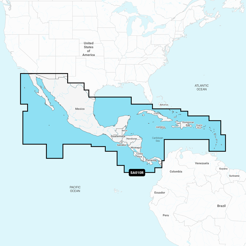
Navionics NASA010R - Central America & Caribbean - Navionics+
Navionics NASA010R - Central America & Caribbean - Navionics+
Online
$99.98for Each
Retail $149.99
Mfr PN: 010-C1459-30
Stock: 0
|
NASA010R - Central America & Caribbean - Navionics+ Get the world’s No. 1 choice in marine mapping - with the best, most up-to-date Navionics+ cartography on a compatible chartplotter. For offshore or inland waters, this all-in-one solution offers detail-rich integrated mapping of coastal waters, lakes, rivers, and more. Get SonarChart™ 1’ (0.5 meters) HD bathymetry maps and advanced features such as dock-to-dock route guidance technology, live mapping, and Plotter Sync to provide wireless access to daily updates. The Navionics Chart Installer software also ensures the freshest chart data every time. Navionics dock-to-dock route guidance solutions suggest a path to follow through channels, inlets, marina entrances, and more. Multiple shading options aid in shallow-water navigation and make it easy to highlight a target depth range for the best fishing spots. Chart Code: NASA010R Coverage Area: Detailed coverage west coast of Mexico from Tijuana to Panama. Including the Panama Canal in its entirety. East Coast coverage from Panama to Brownsville, TX. Also includes detailed Caribbean coverage of the Far Bahamas, Turks & Caicos, Cuba, Jamaica, the Caymans, Haiti, Dominican Republic, Puerto Rico, and the Lesser Antilles To Grenada. Features:
Compatibility:
Technical Specifications:
In the Box:
1Subscription not required for the SonarChart Live mapping feature on some chartplotter models; requires the latest chartplotter firmware release. 2Dock-to-dock Route Guidance is for planning purposes only and does not replace safe navigation operations. *Sold as an Individual |
Online
$99.98for Each
Retail $149.99
Mfr PN: 010-C1459-30
Stock: 0

Navionics NASA012R - Brazil - Navionics+
Navionics NASA012R - Brazil - Navionics+
Online
$99.98for Each
Retail $149.99
Mfr PN: 010-C1461-30
Stock: 2
|
NASA012R - Brazil - Navionics+ Get the world’s No. 1 choice in marine mapping - with the best, most up-to-date Navionics+ cartography on a compatible chartplotter. For offshore or inland waters, this all-in-one solution offers detail-rich integrated mapping of coastal waters, lakes, rivers, and more. Get SonarChart™ 1’ (0.5 meters) HD bathymetry maps and advanced features such as dock-to-dock route guidance technology, live mapping, and Plotter Sync to provide wireless access to daily updates. The Navionics Chart Installer software also ensures the freshest chart data every time. Navionics dock-to-dock route guidance solutions suggest a path to follow through channels, inlets, marina entrances, and more. Multiple shading options aid in shallow-water navigation and make it easy to highlight a target depth range for the best fishing spots. Chart Code: NASA012R Coverage Area:
Features:
Compatibility:
Technical Specifications:
In the Box:
1Subscription not required for the SonarChart Live mapping feature on some chartplotter models; requires the latest chartplotter firmware release. 2Dock-to-dock Route Guidance is for planning purposes only and does not replace safe navigation operations. *Sold as an Individual |
Online
$99.98for Each
Retail $149.99
Mfr PN: 010-C1461-30
Stock: 2

Navionics NAUS001L - U.S. & Coastal Canada - Navionics+
Navionics NAUS001L - U.S. & Coastal Canada - Navionics+
Online
$149.98for Each
Retail $199.99
Mfr PN: 010-C1366-30
Stock: 44
|
NAUS001L - U.S. & Coastal Canada - Navionics+ Get the world’s No. 1 choice in marine mapping - with the best, most up-to-date Navionics+ cartography on your compatible chartplotter. For offshore or inland waters, this all-in-one solution offers detail-rich integrated mapping of coastal waters, lakes, rivers and more. Get SonarChart™ 1’ (0.5 meter) HD bathymetry maps, advanced features such as dock-to-dock route guidance technology, live mapping and Plotter Sync to provide wireless access to daily updates. The Navionics Chart Installer software also ensures the freshest chart data every time out. Navionics dock-to-dock route guidance solutions give you a suggested path to follow through channels, inlets, marina entrances and more. Multiple shading options aid in shallow water navigation and make it easy to highlight a target depth range for the best fishing spots. Chart Code - NAUS001L Coverage Area: Coverage of the entire U.S. coasts, lakes, rivers and inland waterways, plus Alaska and Hawaii. Canada coverage of coastal British Columbia, the Great Lakes, the St. Lawrence Seaway, New Brunswick and Nova Scotia. Coverage includes Bermuda, the Bahamas, Baja California, the Gulf of California, Johnston Atoll and Palmyra Atoll/Kingman Reef. Features:
Compatibility:
Technical Specifications:
In the Box:
1Subscription not required for SonarChart Live mapping feature on some chartplotter models; requires latest chartplotter firmware release. 2Dock-to-dock Route Guidance is for planning purposes only and does not replace safe navigation operations. *Navionics+ and Platinum+ cards are not compatible with Garmin chartplotters. *Sold as an Individual This product may not be returned to the original point of purchase. Please contact the manufacturer directly with any issues or concerns. |
Online
$149.98for Each
Retail $199.99
Mfr PN: 010-C1366-30
Stock: 44

Navionics NAUS005R - U.S. North - Navionics+
Navionics NAUS005R - U.S. North - Navionics+
Online
$99.98for Each
Retail $149.99
Mfr PN: 010-C1368-30
Stock: 0
|
NAUS005R - U.S. North - Navionics+ Get the world’s No. 1 choice in marine mapping - with the best, most up-to-date Navionics+ cartography on your compatible chartplotter. For offshore or inland waters, this all-in-one solution offers detail-rich integrated mapping of coastal waters, lakes, rivers and more. Get SonarChart™ 1’ (0.5 meter) HD bathymetry maps, advanced features such as dock-to-dock route guidance technology, live mapping and Plotter Sync to provide wireless access to daily updates. The Navionics Chart Installer software also ensures the freshest chart data every time out. Navionics dock-to-dock route guidance solutions give you a suggested path to follow through channels, inlets, marina entrances and more. Multiple shading options aid in shallow water navigation and make it easy to highlight a target depth range for the best fishing spots. Chart Code - NAUS005R Coverage Area: Coverage of the lakes and rivers of Iowa, Michigan, Minnesota, North Dakota, South Dakota, Wisconsin, and the U.S. waters of the Great Lakes that border those states. Features:
Compatibility:
Technical Specifications:
In the Box:
1Subscription not required for SonarChart Live mapping feature on some chartplotter models; requires latest chartplotter firmware release. 2Dock-to-dock Route Guidance is for planning purposes only and does not replace safe navigation operations. *Navionics+ and Platinum+ cards are not compatible with Garmin chartplotters. *Sold as an Individual This product may not be returned to the original point of purchase. Please contact the manufacturer directly with any issues or concerns. |
Online
$99.98for Each
Retail $149.99
Mfr PN: 010-C1368-30
Stock: 0

Navionics NAUS006R - U.S. South - Navionics+
Navionics NAUS006R - U.S. South - Navionics+
Online
$99.98for Each
Retail $149.99
Mfr PN: 010-C1369-30
Stock: 0
|
NAUS006R - U.S. South - Navionics+ Get the world’s No. 1 choice in marine mapping - with the best, most up-to-date Navionics+ cartography on your compatible chartplotter. For offshore or inland waters, this all-in-one solution offers detail-rich integrated mapping of coastal waters, lakes, rivers and more. Get SonarChart™ 1’ (0.5 meter) HD bathymetry maps, advanced features such as dock-to-dock route guidance technology, live mapping and Plotter Sync to provide wireless access to daily updates. The Navionics Chart Installer software also ensures the freshest chart data every time out. Navionics dock-to-dock route guidance solutions give you a suggested path to follow through channels, inlets, marina entrances and more. Multiple shading options aid in shallow water navigation and make it easy to highlight a target depth range for the best fishing spots. Chart Code - NAUS006R Coverage Area: Coverage of the lakes, rivers and coasts of Alabama, Arkansas, Florida, Georgia, Kansas, Louisiana, Mississippi, Missouri, Nebraska, New Mexico, Oklahoma, Tennessee, and Texas. Coastal coverage of the Gulf of Mexico, the Atlantic coasts of Florida and Georgia, the Bahamas and the Florida Keys are also included. Features:
Compatibility:
Technical Specifications:
In the Box:
1Subscription not required for SonarChart Live mapping feature on some chartplotter models; requires latest chartplotter firmware release. 2Dock-to-dock Route Guidance is for planning purposes only and does not replace safe navigation operations. *Navionics+ and Platinum+ cards are not compatible with Garmin chartplotters. *Sold as an Individual This product may not be returned to the original point of purchase. Please contact the manufacturer directly with any issues or concerns. |
Online
$99.98for Each
Retail $149.99
Mfr PN: 010-C1369-30
Stock: 0

Navionics NAUS007R - U.S. East - Navionics+
Navionics NAUS007R - U.S. East - Navionics+
Online
$99.98for Each
Retail $149.99
Mfr PN: 010-C1370-30
Stock: 7
|
NAUS007R - U.S. East - Navionics+ Get the world’s No. 1 choice in marine mapping - with the best, most up-to-date Navionics+ cartography on your compatible chartplotter. For offshore or inland waters, this all-in-one solution offers detail-rich integrated mapping of coastal waters, lakes, rivers and more. Get SonarChart™ 1’ (0.5 meter) HD bathymetry maps, advanced features such as dock-to-dock route guidance technology, live mapping and Plotter Sync to provide wireless access to daily updates. The Navionics Chart Installer software also ensures the freshest chart data every time out. Navionics dock-to-dock route guidance solutions give you a suggested path to follow through channels, inlets, marina entrances and more. Multiple shading options aid in shallow water navigation and make it easy to highlight a target depth range for the best fishing spots. Chart Code - NAUS007R Coverage Area: Coverage of the lakes, rivers and coasts of Connecticut, Delaware, Illinois, Indiana, Kentucky, Maine, Maryland, Massachusetts, Michigan, New Hampshire, New Jersey, New York, North Carolina, Ohio, Pennsylvania, Rhode Island, South Carolina, Tennessee, Vermont, Virginia and West Virginia. Features:
Compatibility:
Technical Specifications:
In the Box:
1Subscription not required for SonarChart Live mapping feature on some chartplotter models; requires latest chartplotter firmware release. 2Dock-to-dock Route Guidance is for planning purposes only and does not replace safe navigation operations. *Navionics+ and Platinum+ cards are not compatible with Garmin chartplotters. *Sold as an Individual This product may not be returned to the original point of purchase. Please contact the manufacturer directly with any issues or concerns. |
Online
$99.98for Each
Retail $149.99
Mfr PN: 010-C1370-30
Stock: 7

Navionics NAUS013R - Canada, West & Alaska - Navionics+
Navionics NAUS013R - Canada, West & Alaska - Navionics+
Online
$99.98for Each
Retail $149.99
Mfr PN: 010-C1467-30
Stock: 3
|
NAUS013R - Canada, West & Alaska - Navionics+ Get the world’s No. 1 choice in marine mapping - with the best, most up-to-date Navionics+ cartography on your compatible chartplotter. For offshore or inland waters, this all-in-one solution offers detail-rich integrated mapping of coastal waters, lakes, rivers, and more. Get SonarChart™ 1’ (0.5 meters) HD bathymetry maps, advanced features such as dock-to-dock route guidance technology, live mapping, and Plotter Sync to provide wireless access to daily updates. The Navionics Chart Installer software also ensures the freshest chart data every time. Navionics dock-to-dock route guidance solutions suggest a path to follow through channels, inlets, marina entrances, and more. Multiple shading options aid in shallow water navigation and make it easy to highlight a target depth range for the best fishing spots. Chart Code: NAUS013R Coverage Area Detailed coverage of coastal and inland waterways of western Canada and Alaska. Coverage includes Vancouver Island, Puget Sound, and the Aleutian Islands. Features All-In-One Map Solution Access detail-rich mapping of coastal features, lakes, rivers, and more on a wide range of compatible chartplotters. Integrated coastal and inland lake content offers coverage for boaters worldwide. Daily Chart Updates Charts are constantly being enhanced with new and amended content — thousands of updates are made every day. The included 1-year subscription gives you access to daily chart updates via the Navionics chart installer software. Dock-To-Dock Route Guidance Advanced route guidance technology2 uses boat settings, along with chart data and frequently traveled routes, to calculate a suggested path to follow from dock to dock. Up to 1’ Contours For improved fishing and navigation, up to 1' contours provide a clear depiction of bottom structure for fishing charts as well as enhanced detail in swamps, canals, harbors, marinas, and more. Advanced Map Options Change the way you view Navionics charts to focus on the details that matter most to users. Highlight shallow areas, adjust contour density, or select a fishing range. Community Edits Download community edits for useful local knowledge added by users of the Navionics Boating app, and view the data on a compatible chartplotter. Plotter Sync Transfer routes and markers, update charts, and more between your plotter card and mobile app — wirelessly. Users can even activate or renew their cartography subscription and upload sonar logs4. Sonarchart™ Live Mapping Create maps on the fly. Watch new 1’ HD bathymetry maps develop in real-time as the boat moves through the water. Compatibility:
Technical Specifications:
In the Box:
1Navionics+ and Navionics Platinum+ cards are not compatible with Garmin chartplotters 2Route guidance is for planning purposes only and does not replace safe navigation operations 3Renewing a subscription, without lapsing, costs up to 50% less than purchasing the same updates and content via a new card or new subscription 4The plotter sync feature requires the use of the Navionics Boating app on your compatible smart device with an active subscription in the same area *Sold as an Individual |
Online
$99.98for Each
Retail $149.99
Mfr PN: 010-C1467-30
Stock: 3

Navionics Platinum+ NPSA004L - Mexico, Caribbean to Brazil
Navionics Platinum+ NPSA004L - Mexico, Caribbean to Brazil
Online
$299.98for Each
Retail $399.99
Mfr PN: 010-C1364-40
Stock: 7
|
NPSA004L - Mexico, Caribbean to Brazil Get the world’s No. 1 choice in marine mapping - with the best, most up-to-date Navionics Platinum+ cartography on your compatible chartplotter. For offshore or inland waters, this all-in-one solution offers detail-rich integrated mapping of coastal waters, lakes, rivers and more. Get SonarChart™ 1’ (0.5 meter) HD bathymetry maps, advanced features such as dock-to-dock route guidance technology, live mapping and Plotter Sync to provide wireless access to daily updates. The Navionics Chart Installer software also ensures the freshest chart data every time out. Navionics dock-to-dock route guidance solutions give you a suggested path to follow through channels, inlets, marina entrances and more. Multiple shading options aid in shallow water navigation and make it easy to highlight a target depth range for the best fishing spots. Navionics Platinum+™ charts include all the content of Navionics®+ cartography, with integrated offshore and inland mapping, 42,000+ lakes and additional viewing options for relief shading, satellite imagery with SonarChart shading overlay, 3D perspective view, aerial photos, and more. Chart Code - NPSA0004L Coverage Area: Coverage of Mexico, Central America and Brazil. Coverage includes the US Gulf Coast and the eastern US coast to Savannah, GA; Bermuda; the Bahamas; Cuba; Hispaniola; Puerto Rico and the Virgin Islands; the Windward and Leeward Islands; Jamaica; the Panama Canal, the western coast of South America to Arica, Chile; the Galapagos Islands; the Revillagigedo Islands; the Ilha Fernando de Noronha; the Saint Peter and Saint Paul Archipelago and the Rocas Atoll. Features:
Compatibility:
Technical Specifications:
In the Box:
1Subscription not required for SonarChart Live mapping feature on some chartplotter models; requires latest chartplotter firmware release. 2Dock-to-dock Route Guidance is for planning purposes only and does not replace safe navigation operations. *Navionics+ and Platinum+ cards are not compatible with Garmin chartplotters. *Sold as an Individual This product may not be returned to the original point of purchase. Please contact the manufacturer directly with any issues or concerns. |
Online
$299.98for Each
Retail $399.99
Mfr PN: 010-C1364-40
Stock: 7

Navionics Platinum+ NPUS004R - Canada & Alaska
Navionics Platinum+ NPUS004R - Canada & Alaska
Online
$149.98for Each
Retail $249.99
Mfr PN: 010-C1367-40
Stock: 5
|
NPUS004R - Canada & Alaska Get the world’s No. 1 choice in marine mapping - with the best, most up-to-date Navionics Platinum+ cartography on your compatible chartplotter. For offshore or inland waters, this all-in-one solution offers detail-rich integrated mapping of coastal waters, lakes, rivers and more. Get SonarChart™ 1’ (0.5 meter) HD bathymetry maps, advanced features such as dock-to-dock route guidance technology, live mapping and Plotter Sync to provide wireless access to daily updates. The Navionics Chart Installer software also ensures the freshest chart data every time out. Navionics dock-to-dock route guidance solutions give you a suggested path to follow through channels, inlets, marina entrances and more. Multiple shading options aid in shallow water navigation and make it easy to highlight a target depth range for the best fishing spots. Navionics Platinum+™ charts include all the content of Navionics®+ cartography, with integrated offshore and inland mapping, 42,000+ lakes and additional viewing options for relief shading, satellite imagery with SonarChart shading overlay, 3D perspective view, aerial photos, and more. Chart Code - NPUS004R Coverage Area: Coverage of the Atlantic and Pacific coasts, inland lakes and waterways of Alaska and Canada (except YT and NU). Coverage includes the Aleutian Islands, Vancouver Island, Puget Sound, the St Lawrence River, the Maritime Provinces and the Grand Banks. Features:
Compatibility:
Technical Specifications:
In the Box:
1Subscription not required for SonarChart Live mapping feature on some chartplotter models; requires latest chartplotter firmware release. 2Dock-to-dock Route Guidance is for planning purposes only and does not replace safe navigation operations. *Navionics+ and Platinum+ cards are not compatible with Garmin chartplotters. *Sold as an Individual This product may not be returned to the original point of purchase. Please contact the manufacturer directly with any issues or concerns. |
Online
$149.98for Each
Retail $249.99
Mfr PN: 010-C1367-40
Stock: 5

Navionics Platinum+ NPUS005R - U.S. North
Navionics Platinum+ NPUS005R - U.S. North
Online
$149.98for Each
Retail $249.99
Mfr PN: 010-C1368-40
Stock: 4
|
NPUS005R - U.S. North Get the world’s No. 1 choice in marine mapping - with the best, most up-to-date Navionics Platinum+ cartography on your compatible chartplotter. For offshore or inland waters, this all-in-one solution offers detail-rich integrated mapping of coastal waters, lakes, rivers and more. Get SonarChart™ 1’ (0.5 meter) HD bathymetry maps, advanced features such as dock-to-dock route guidance technology, live mapping and Plotter Sync to provide wireless access to daily updates. The Navionics Chart Installer software also ensures the freshest chart data every time out. Navionics dock-to-dock route guidance solutions give you a suggested path to follow through channels, inlets, marina entrances and more. Multiple shading options aid in shallow water navigation and make it easy to highlight a target depth range for the best fishing spots. Navionics Platinum+™ charts include all the content of Navionics®+ cartography, with integrated offshore and inland mapping, 42,000+ lakes and additional viewing options for relief shading, satellite imagery with SonarChart shading overlay, 3D perspective view, aerial photos, and more. Chart Code - NPUS005R Coverage Area: Coverage of the lakes and rivers of Iowa, Michigan, Minnesota, North Dakota, South Dakota, Wisconsin, and the U.S. waters of the Great Lakes that border those states. Features:
Compatibility:
Technical Specifications:
In the Box:
1Subscription not required for SonarChart Live mapping feature on some chartplotter models; requires latest chartplotter firmware release. 2Dock-to-dock Route Guidance is for planning purposes only and does not replace safe navigation operations. *Navionics+ and Platinum+ cards are not compatible with Garmin chartplotters. *Sold as an Individual This product may not be returned to the original point of purchase. Please contact the manufacturer directly with any issues or concerns. |
Online
$149.98for Each
Retail $249.99
Mfr PN: 010-C1368-40
Stock: 4

Navionics Platinum+ NPUS007R - U.S. East
Navionics Platinum+ NPUS007R - U.S. East
Online
$149.98for Each
Retail $249.99
Mfr PN: 010-C1370-40
Stock: 23
|
NPUS007R - U.S. East Get the world’s No. 1 choice in marine mapping - with the best, most up-to-date Navionics Platinum+ cartography on your compatible chartplotter. For offshore or inland waters, this all-in-one solution offers detail-rich integrated mapping of coastal waters, lakes, rivers and more. Get SonarChart™ 1’ (0.5 meter) HD bathymetry maps, advanced features such as dock-to-dock route guidance technology, live mapping and Plotter Sync to provide wireless access to daily updates. The Navionics Chart Installer software also ensures the freshest chart data every time out. Navionics dock-to-dock route guidance solutions give you a suggested path to follow through channels, inlets, marina entrances and more. Multiple shading options aid in shallow water navigation and make it easy to highlight a target depth range for the best fishing spots. Navionics Platinum+™ charts include all the content of Navionics®+ cartography, with integrated offshore and inland mapping, 42,000+ lakes and additional viewing options for relief shading, satellite imagery with SonarChart shading overlay, 3D perspective view, aerial photos, and more. Chart Code - NPUS007R Coverage Area: Coverage of the lakes, rivers and coasts of Connecticut, Delaware, Illinois, Indiana, Kentucky, Maine, Maryland, Massachusetts, Michigan, New Hampshire, New Jersey, New York, North Carolina, Ohio, Pennsylvania, Rhode Island, South Carolina, Tennessee, Vermont, Virginia and West Virginia. Features:
Compatibility:
Technical Specifications:
In the Box:
1Subscription not required for SonarChart Live mapping feature on some chartplotter models; requires latest chartplotter firmware release. 2Dock-to-dock Route Guidance is for planning purposes only and does not replace safe navigation operations. *Navionics+ and Platinum+ cards are not compatible with Garmin chartplotters. *Sold as an Individual This product may not be returned to the original point of purchase. Please contact the manufacturer directly with any issues or concerns. |
Online
$149.98for Each
Retail $249.99
Mfr PN: 010-C1370-40
Stock: 23
|
|
|
|
Copyright © 1999-2024 BuilderDepot, Inc. Site Designed and Maintained by Inline Internet Systems, Inc. |