
Browse In:
Shop by Brand: Garmin
Sort by
Items 1-
32
of 640 total

Garmin BlueChart g3 Vision HD - VEU469S - Stockholm & Mälaren - microSD/SD
Garmin BlueChart g3 Vision HD - VEU469S - Stockholm & Mälaren - microSD/SD
Online
$174.97for Each
Retail $174.99
Mfr PN: 010-C0813-00
Stock: 0
|
BlueChart® g3 Vision® HD - VEU469S - Stockholm & Mälaren - microSD™/SD™ Coverage: Detailed coverage of the coast of Sweden from Öregrund to Norrkoping. Also includes detailed coverage of Norrtalje, Stockholm and Södertälje, as well as coverage of the lower Dalälven from Gysinge to Söderfors. Premier Coastal Charts
Experience unparalleled coverage and brilliant detail when you’re on the water. BlueChart g3 Vision coastal charts provide industry-leading coverage, clarity and detail with integrated Garmin and Navionics content. Auto Guidance Whether you are fishing or cruising, select a spot, and get a route showing you the general path and nearby obstructions at a safe depth1. Depth Range Shading This feature displays high-resolution Depth Range Shading for up to 10 depth ranges so you can view your designated target depth. Shallow Water Shading To give a clear picture of shallow waters to avoid, this feature allows for shading at a user-defined depth. Detailed Contours BlueChart g3 Vision charts feature 1’ contours that provide a more accurate depiction of bottom structure for improved fishing charts and enhanced detail in swamps, canals and port plans. High-resolution Satellite Imagery High-resolution satellite imagery with navigational charts overlaid gives you a realistic view of your surroundings. It’s our most realistic charting display in a chartplotter — ideal for entering unfamiliar harbors or ports. FishEye View This underwater perspective shows 3-D representation of bottom and contours as seen from below the waterline. Interface with sonar data for a customized view. MarinerEye View This view provides a 3-D representation of the surrounding area both above and below the waterline. Aerial Photography Crystal-clear aerial photography shows exceptional detail of many ports, harbors and marinas and is ideal when entering unfamiliar ports. ¹Auto Guidance is for planning purposes only and does not replace safe navigation practices
|
 WARNING: This product can expose you to chemicals which are known to the State of California to cause cancer, birth defects or other reproductive harm. For more information go to
 Online
$174.97for Each
Retail $174.99
Mfr PN: 010-C0813-00
Stock: 0

Garmin BlueChart g3 Vision HD - VEU470S - Stromstad to Halmstad - microSD/SD
Garmin BlueChart g3 Vision HD - VEU470S - Stromstad to Halmstad - microSD/SD
Online
$174.97for Each
Retail $174.99
Mfr PN: 010-C0814-00
Stock: 0
|
BlueChart® g3 Vision® HD - VEU470S - Stromstad to Halmstad - microSD™/SD™ Coverage: Detailed coverage of lakes Vänern, Vättern, Mjörn, Sommen, Nommen, and Bolmen, as well as the coast of Sweden from Stromstad to Halmstad. Also contains coverage of the Danish coast from Hirtshals through Alborg Bugt. Includes detailed coverage of Gteborg, Vanersborg, Karlstad, and Karlsborg, Swe.; Frederikshavn, Den.; and Laeso. Includes coverage of the Skagerrak and Kattegat water bodies. Premier Coastal Charts
Experience unparalleled coverage and brilliant detail when you’re on the water. BlueChart g3 Vision coastal charts provide industry-leading coverage, clarity and detail with integrated Garmin and Navionics content. Auto Guidance Whether you are fishing or cruising, select a spot, and get a route showing you the general path and nearby obstructions at a safe depth1. Depth Range Shading This feature displays high-resolution Depth Range Shading for up to 10 depth ranges so you can view your designated target depth. Shallow Water Shading To give a clear picture of shallow waters to avoid, this feature allows for shading at a user-defined depth. Detailed Contours BlueChart g3 Vision charts feature 1’ contours that provide a more accurate depiction of bottom structure for improved fishing charts and enhanced detail in swamps, canals and port plans. High-resolution Satellite Imagery High-resolution satellite imagery with navigational charts overlaid gives you a realistic view of your surroundings. It’s our most realistic charting display in a chartplotter — ideal for entering unfamiliar harbors or ports. FishEye View This underwater perspective shows 3-D representation of bottom and contours as seen from below the waterline. Interface with sonar data for a customized view. MarinerEye View This view provides a 3-D representation of the surrounding area both above and below the waterline. Aerial Photography Crystal-clear aerial photography shows exceptional detail of many ports, harbors and marinas and is ideal when entering unfamiliar ports. ¹Auto Guidance is for planning purposes only and does not replace safe navigation practices
|
Online
$174.97for Each
Retail $174.99
Mfr PN: 010-C0814-00
Stock: 0

Garmin BlueChart g3 Vision HD - VEU471S - Gulf of Bothnia - microSD/SD
Garmin BlueChart g3 Vision HD - VEU471S - Gulf of Bothnia - microSD/SD
Online
$174.97for Each
Retail $174.99
Mfr PN: 010-C0815-00
Stock: 0
|
BlueChart® g3 Vision® HD - VEU471S - Gulf of Bothnia - microSD™/SD™ Coverage: Detailed coverage of the Southern portion of the Gulf of Bothnia from Iggesund to Öregrund in Sweden and the cities of Pori and Rauma in Finland. Also includes detailed coverage of the cities of Hudiksvall, Gavle, Soderhamn, and Grisslehamn, as well as coverage of the lower Dallven from Gysinge to Söderfors, Swe. and the island of Åland, Fin. Premier Coastal Charts
Experience unparalleled coverage and brilliant detail when you’re on the water. BlueChart g3 Vision coastal charts provide industry-leading coverage, clarity and detail with integrated Garmin and Navionics content. Auto Guidance Whether you are fishing or cruising, select a spot, and get a route showing you the general path and nearby obstructions at a safe depth1. Depth Range Shading This feature displays high-resolution Depth Range Shading for up to 10 depth ranges so you can view your designated target depth. Shallow Water Shading To give a clear picture of shallow waters to avoid, this feature allows for shading at a user-defined depth. Detailed Contours BlueChart g3 Vision charts feature 1’ contours that provide a more accurate depiction of bottom structure for improved fishing charts and enhanced detail in swamps, canals and port plans. High-resolution Satellite Imagery High-resolution satellite imagery with navigational charts overlaid gives you a realistic view of your surroundings. It’s our most realistic charting display in a chartplotter — ideal for entering unfamiliar harbors or ports. FishEye View This underwater perspective shows 3-D representation of bottom and contours as seen from below the waterline. Interface with sonar data for a customized view. MarinerEye View This view provides a 3-D representation of the surrounding area both above and below the waterline. Aerial Photography Crystal-clear aerial photography shows exceptional detail of many ports, harbors and marinas and is ideal when entering unfamiliar ports. ¹Auto Guidance is for planning purposes only and does not replace safe navigation practices
|
Online
$174.97for Each
Retail $174.99
Mfr PN: 010-C0815-00
Stock: 0

Garmin BlueChart g3 Vision HD - VEU472S - Gulf of Bothnia, Center - microSD/SD
Garmin BlueChart g3 Vision HD - VEU472S - Gulf of Bothnia, Center - microSD/SD
Online
$174.97for Each
Retail $174.99
Mfr PN: 010-C0816-00
Stock: 0
|
BlueChart® g3 Vision® HD - VEU472S - Gulf of Bothnia, Center - microSD™/SD™ Coverage: Detailed coverage of the central portion of the Gulf of Bothnia from Umea to Soderhamn in Sweden and from Himanka to Pori in Finland. Also includes detailed coverage of Harnosand, Hudiksvall, Bygdea, and lake Storsjn in Sweden, as well as the cities of Pietarsaari and Vassa in Finland, and the island of Vallgrund. Premier Coastal Charts
Experience unparalleled coverage and brilliant detail when you’re on the water. BlueChart g3 Vision coastal charts provide industry-leading coverage, clarity and detail with integrated Garmin and Navionics content. Auto Guidance Whether you are fishing or cruising, select a spot, and get a route showing you the general path and nearby obstructions at a safe depth1. Depth Range Shading This feature displays high-resolution Depth Range Shading for up to 10 depth ranges so you can view your designated target depth. Shallow Water Shading To give a clear picture of shallow waters to avoid, this feature allows for shading at a user-defined depth. Detailed Contours BlueChart g3 Vision charts feature 1’ contours that provide a more accurate depiction of bottom structure for improved fishing charts and enhanced detail in swamps, canals and port plans. High-resolution Satellite Imagery High-resolution satellite imagery with navigational charts overlaid gives you a realistic view of your surroundings. It’s our most realistic charting display in a chartplotter — ideal for entering unfamiliar harbors or ports. FishEye View This underwater perspective shows 3-D representation of bottom and contours as seen from below the waterline. Interface with sonar data for a customized view. MarinerEye View This view provides a 3-D representation of the surrounding area both above and below the waterline. Aerial Photography Crystal-clear aerial photography shows exceptional detail of many ports, harbors and marinas and is ideal when entering unfamiliar ports. ¹Auto Guidance is for planning purposes only and does not replace safe navigation practices
|
Online
$174.97for Each
Retail $174.99
Mfr PN: 010-C0816-00
Stock: 0

Garmin BlueChart g3 Vision HD - VEU473S - Gulf of Bothnia, North - microSD/SD
Garmin BlueChart g3 Vision HD - VEU473S - Gulf of Bothnia, North - microSD/SD
Online
$174.97for Each
Retail $174.99
Mfr PN: 010-C0817-00
Stock: 0
|
BlueChart® g3 Vision® HD - VEU473S - Gulf of Bothnia, North - microSD™/SD™ Coverage: Detailed coverage of the Northern portion of the Gulf of Bothnia from Umea, Sweden to Vassa, Finland. Coverage includes lakes Tjeggelvas, Hornavan, Uddjaur, Aisjaur, Fluka, and Storavan in Sweden. Also includes detailed coverage of the cities of Pietarsaari and Oulu in Finland and Lulea and Happaranda in Sweden, and the islands of Vallgrund and Hailuoto. Premier Coastal Charts
Experience unparalleled coverage and brilliant detail when you’re on the water. BlueChart g3 Vision coastal charts provide industry-leading coverage, clarity and detail with integrated Garmin and Navionics content. Auto Guidance Whether you are fishing or cruising, select a spot, and get a route showing you the general path and nearby obstructions at a safe depth1. Depth Range Shading This feature displays high-resolution Depth Range Shading for up to 10 depth ranges so you can view your designated target depth. Shallow Water Shading To give a clear picture of shallow waters to avoid, this feature allows for shading at a user-defined depth. Detailed Contours BlueChart g3 Vision charts feature 1’ contours that provide a more accurate depiction of bottom structure for improved fishing charts and enhanced detail in swamps, canals and port plans. High-resolution Satellite Imagery High-resolution satellite imagery with navigational charts overlaid gives you a realistic view of your surroundings. It’s our most realistic charting display in a chartplotter — ideal for entering unfamiliar harbors or ports. FishEye View This underwater perspective shows 3-D representation of bottom and contours as seen from below the waterline. Interface with sonar data for a customized view. MarinerEye View This view provides a 3-D representation of the surrounding area both above and below the waterline. Aerial Photography Crystal-clear aerial photography shows exceptional detail of many ports, harbors and marinas and is ideal when entering unfamiliar ports. ¹Auto Guidance is for planning purposes only and does not replace safe navigation practices
|
Online
$174.97for Each
Retail $174.99
Mfr PN: 010-C0817-00
Stock: 0

Garmin BlueChart g3 Vision HD - VEU474S - Alborg to the Eider - microSD/SD
Garmin BlueChart g3 Vision HD - VEU474S - Alborg to the Eider - microSD/SD
Online
$174.97for Each
Retail $174.99
Mfr PN: 010-C0818-00
Stock: 0
|
BlueChart® g3 Vision® HD - VEU474S - Alborg to the Eider - microSD™/SD™ Coverage: Detailed coverage of the Northern and Western coasts of Denmark from Ålborg Bugt to Cuxhaven, Germany. Also includes detailed coverage of the cities of Skagen, Thisted, and Esbjerg as well as the Jammerbugten water body. Premier Coastal Charts
Experience unparalleled coverage and brilliant detail when you’re on the water. BlueChart g3 Vision coastal charts provide industry-leading coverage, clarity and detail with integrated Garmin and Navionics content. Auto Guidance Whether you are fishing or cruising, select a spot, and get a route showing you the general path and nearby obstructions at a safe depth1. Depth Range Shading This feature displays high-resolution Depth Range Shading for up to 10 depth ranges so you can view your designated target depth. Shallow Water Shading To give a clear picture of shallow waters to avoid, this feature allows for shading at a user-defined depth. Detailed Contours BlueChart g3 Vision charts feature 1’ contours that provide a more accurate depiction of bottom structure for improved fishing charts and enhanced detail in swamps, canals and port plans. High-resolution Satellite Imagery High-resolution satellite imagery with navigational charts overlaid gives you a realistic view of your surroundings. It’s our most realistic charting display in a chartplotter — ideal for entering unfamiliar harbors or ports. FishEye View This underwater perspective shows 3-D representation of bottom and contours as seen from below the waterline. Interface with sonar data for a customized view. MarinerEye View This view provides a 3-D representation of the surrounding area both above and below the waterline. Aerial Photography Crystal-clear aerial photography shows exceptional detail of many ports, harbors and marinas and is ideal when entering unfamiliar ports. ¹Auto Guidance is for planning purposes only and does not replace safe navigation practices
|
Online
$174.97for Each
Retail $174.99
Mfr PN: 010-C0818-00
Stock: 0

Garmin BlueChart g3 Vision HD - VEU479S - Portugal - microSD/SD
Garmin BlueChart g3 Vision HD - VEU479S - Portugal - microSD/SD
Online
$174.97for Each
Retail $174.99
Mfr PN: 010-C0823-00
Stock: 0
|
BlueChart® g3 Vision® HD - VEU479S - Portugal - microSD™/SD™ Coverage: From Vigo, Spain Atlantic coast to Cabo de Sao Vicente to Ayamonte. Also including Viana Do Castelo, Porto, Aveiro, Figueira Da Foz, Nazaré, Peniche, Lisbon, Sesimbra, Sines, Ponta De Sagres, Lagos, Portimao, Vilamoura and Faro. Premier Coastal Charts
Experience unparalleled coverage and brilliant detail when you’re on the water. BlueChart g3 Vision coastal charts provide industry-leading coverage, clarity and detail with integrated Garmin and Navionics content. Auto Guidance Whether you are fishing or cruising, select a spot, and get a route showing you the general path and nearby obstructions at a safe depth1. Depth Range Shading This feature displays high-resolution Depth Range Shading for up to 10 depth ranges so you can view your designated target depth. Shallow Water Shading To give a clear picture of shallow waters to avoid, this feature allows for shading at a user-defined depth. Detailed Contours BlueChart g3 Vision charts feature 1’ contours that provide a more accurate depiction of bottom structure for improved fishing charts and enhanced detail in swamps, canals and port plans. High-resolution Satellite Imagery High-resolution satellite imagery with navigational charts overlaid gives you a realistic view of your surroundings. It’s our most realistic charting display in a chartplotter — ideal for entering unfamiliar harbors or ports. FishEye View This underwater perspective shows 3-D representation of bottom and contours as seen from below the waterline. Interface with sonar data for a customized view. MarinerEye View This view provides a 3-D representation of the surrounding area both above and below the waterline. Aerial Photography Crystal-clear aerial photography shows exceptional detail of many ports, harbors and marinas and is ideal when entering unfamiliar ports. ¹Auto Guidance is for planning purposes only and does not replace safe navigation practices
|
Online
$174.97for Each
Retail $174.99
Mfr PN: 010-C0823-00
Stock: 0

Garmin BlueChart g3 Vision HD - VEU482S - Wexford to Dingle Bay - microSD/SD
Garmin BlueChart g3 Vision HD - VEU482S - Wexford to Dingle Bay - microSD/SD
Online
$174.97for Each
Retail $174.99
Mfr PN: 010-C0826-00
Stock: 0
|
BlueChart® g3 Vision® HD - Wexford to Dingle Bay - microSD™/SD™ Coverage: Detailed coverage of Southern Ireland from Wexford to Ventry. Also includes detailed coverage of Dungarvan, Cork, and Cahersiveen. Premier Coastal Charts
Experience unparalleled coverage and brilliant detail when you’re on the water. BlueChart g3 Vision coastal charts provide industry-leading coverage, clarity and detail with integrated Garmin and Navionics content. Auto Guidance Whether you are fishing or cruising, select a spot, and get a route showing you the general path and nearby obstructions at a safe depth1. Depth Range Shading This feature displays high-resolution Depth Range Shading for up to 10 depth ranges so you can view your designated target depth. Shallow Water Shading To give a clear picture of shallow waters to avoid, this feature allows for shading at a user-defined depth. Detailed Contours BlueChart g3 Vision charts feature 1’ contours that provide a more accurate depiction of bottom structure for improved fishing charts and enhanced detail in swamps, canals and port plans. High-resolution Satellite Imagery High-resolution satellite imagery with navigational charts overlaid gives you a realistic view of your surroundings. It’s our most realistic charting display in a chartplotter — ideal for entering unfamiliar harbors or ports. FishEye View This underwater perspective shows 3-D representation of bottom and contours as seen from below the waterline. Interface with sonar data for a customized view. MarinerEye View This view provides a 3-D representation of the surrounding area both above and below the waterline. Aerial Photography Crystal-clear aerial photography shows exceptional detail of many ports, harbors and marinas and is ideal when entering unfamiliar ports. ¹Auto Guidance is for planning purposes only and does not replace safe navigation practices
|
Online
$174.97for Each
Retail $174.99
Mfr PN: 010-C0826-00
Stock: 0

Garmin BlueChart g3 Vision HD - VEU483S - Galway Bay to Cork - microSD/SD
Garmin BlueChart g3 Vision HD - VEU483S - Galway Bay to Cork - microSD/SD
Online
$174.97for Each
Retail $174.99
Mfr PN: 010-C0827-00
Stock: 0
|
BlueChart® g3 Vision® HD - VEU483S - Galway Bay to Cork - microSD™/SD™ Coverage: Detailed coverage of Southwestern Ireland from Kilkieran to Cork. Also includes detailed coverage of Galway Bay, Tarbert, and Tralee. Premier Coastal Charts
Experience unparalleled coverage and brilliant detail when you’re on the water. BlueChart g3 Vision coastal charts provide industry-leading coverage, clarity and detail with integrated Garmin and Navionics content. Auto Guidance Whether you are fishing or cruising, select a spot, and get a route showing you the general path and nearby obstructions at a safe depth1. Depth Range Shading This feature displays high-resolution Depth Range Shading for up to 10 depth ranges so you can view your designated target depth. Shallow Water Shading To give a clear picture of shallow waters to avoid, this feature allows for shading at a user-defined depth. Detailed Contours BlueChart g3 Vision charts feature 1’ contours that provide a more accurate depiction of bottom structure for improved fishing charts and enhanced detail in swamps, canals and port plans. High-resolution Satellite Imagery High-resolution satellite imagery with navigational charts overlaid gives you a realistic view of your surroundings. It’s our most realistic charting display in a chartplotter — ideal for entering unfamiliar harbors or ports. FishEye View This underwater perspective shows 3-D representation of bottom and contours as seen from below the waterline. Interface with sonar data for a customized view. MarinerEye View This view provides a 3-D representation of the surrounding area both above and below the waterline. Aerial Photography Crystal-clear aerial photography shows exceptional detail of many ports, harbors and marinas and is ideal when entering unfamiliar ports. ¹Auto Guidance is for planning purposes only and does not replace safe navigation practices
|
Online
$174.97for Each
Retail $174.99
Mfr PN: 010-C0827-00
Stock: 0

Garmin BlueChart g3 Vision HD - VEU484S - Ireland North-West - microSD/SD
Garmin BlueChart g3 Vision HD - VEU484S - Ireland North-West - microSD/SD
Online
$174.97for Each
Retail $174.99
Mfr PN: 010-C0828-00
Stock: 0
|
BlueChart® g3 Vision® HD - VEU484S - Ireland North-West - microSD™/SD™ Coverage: Detailed coverage of Northwestern Ireland from Londonderry to Galway Bay. Also includes detailed coverage of Sligo, Ballina, Galway, and Donegal Bay. Premier Coastal Charts
Experience unparalleled coverage and brilliant detail when you’re on the water. BlueChart g3 Vision coastal charts provide industry-leading coverage, clarity and detail with integrated Garmin and Navionics content. Auto Guidance Whether you are fishing or cruising, select a spot, and get a route showing you the general path and nearby obstructions at a safe depth1. Depth Range Shading This feature displays high-resolution Depth Range Shading for up to 10 depth ranges so you can view your designated target depth. Shallow Water Shading To give a clear picture of shallow waters to avoid, this feature allows for shading at a user-defined depth. Detailed Contours BlueChart g3 Vision charts feature 1’ contours that provide a more accurate depiction of bottom structure for improved fishing charts and enhanced detail in swamps, canals and port plans. High-resolution Satellite Imagery High-resolution satellite imagery with navigational charts overlaid gives you a realistic view of your surroundings. It’s our most realistic charting display in a chartplotter — ideal for entering unfamiliar harbors or ports. FishEye View This underwater perspective shows 3-D representation of bottom and contours as seen from below the waterline. Interface with sonar data for a customized view. MarinerEye View This view provides a 3-D representation of the surrounding area both above and below the waterline. Aerial Photography Crystal-clear aerial photography shows exceptional detail of many ports, harbors and marinas and is ideal when entering unfamiliar ports. ¹Auto Guidance is for planning purposes only and does not replace safe navigation practices
|
Online
$174.97for Each
Retail $174.99
Mfr PN: 010-C0828-00
Stock: 0

Garmin BlueChart g3 Vision HD - VEU485S - Fuenterrabia to Gijon - microSD/SD
Garmin BlueChart g3 Vision HD - VEU485S - Fuenterrabia to Gijon - microSD/SD
Online
$174.97for Each
Retail $174.99
Mfr PN: 010-C0829-00
Stock: 0
|
BlueChart® g3 Vision® HD - VEU485S - Fuenterrabia to Gijon - microSD™/SD™ Coverage: From Arcachon, France to Candas, Spain. Also including Cap Breton, Bayonne, San Sebastian, Guetaria, Motrico, Bermeo, Las Arenas, Bilbao, Castro Urdides, Santoña, Suances, Ribadesella and Tazones. Premier Coastal Charts
Experience unparalleled coverage and brilliant detail when you’re on the water. BlueChart g3 Vision coastal charts provide industry-leading coverage, clarity and detail with integrated Garmin and Navionics content. Auto Guidance Whether you are fishing or cruising, select a spot, and get a route showing you the general path and nearby obstructions at a safe depth1. Depth Range Shading This feature displays high-resolution Depth Range Shading for up to 10 depth ranges so you can view your designated target depth. Shallow Water Shading To give a clear picture of shallow waters to avoid, this feature allows for shading at a user-defined depth. Detailed Contours BlueChart g3 Vision charts feature 1’ contours that provide a more accurate depiction of bottom structure for improved fishing charts and enhanced detail in swamps, canals and port plans. High-resolution Satellite Imagery High-resolution satellite imagery with navigational charts overlaid gives you a realistic view of your surroundings. It’s our most realistic charting display in a chartplotter — ideal for entering unfamiliar harbors or ports. FishEye View This underwater perspective shows 3-D representation of bottom and contours as seen from below the waterline. Interface with sonar data for a customized view. MarinerEye View This view provides a 3-D representation of the surrounding area both above and below the waterline. Aerial Photography Crystal-clear aerial photography shows exceptional detail of many ports, harbors and marinas and is ideal when entering unfamiliar ports. ¹Auto Guidance is for planning purposes only and does not replace safe navigation practices
|
Online
$174.97for Each
Retail $174.99
Mfr PN: 010-C0829-00
Stock: 0

Garmin BlueChart g3 Vision HD - VEU486S - Galicia & Asturias - microSD/SD
Garmin BlueChart g3 Vision HD - VEU486S - Galicia & Asturias - microSD/SD
Online
$174.97for Each
Retail $174.99
Mfr PN: 010-C0830-00
Stock: 0
|
BlueChart® g3 Vision® HD - VEU486S - Galicia & Asturias - microSD™/SD™ Coverage: From Cabo Ajo, Spain to Praia da Aguda, Portugal. Also including Suances, Ribadesella, Tazones, Gijon, Candas, Aviles, San Juan de la Arena, Cudillero, Navia, Figueras, Burela, Los Farallones, Vivero, Ensenada de Cariño, Cedeira, El Ferrol del Candillo, La Coruña, Camarias, Finisterre, Corcubion, Villagarcia, Marin, Vigo, Viana do Castelo and Porto. Premier Coastal Charts
Experience unparalleled coverage and brilliant detail when you’re on the water. BlueChart g3 Vision coastal charts provide industry-leading coverage, clarity and detail with integrated Garmin and Navionics content. Auto Guidance Whether you are fishing or cruising, select a spot, and get a route showing you the general path and nearby obstructions at a safe depth1. Depth Range Shading This feature displays high-resolution Depth Range Shading for up to 10 depth ranges so you can view your designated target depth. Shallow Water Shading To give a clear picture of shallow waters to avoid, this feature allows for shading at a user-defined depth. Detailed Contours BlueChart g3 Vision charts feature 1’ contours that provide a more accurate depiction of bottom structure for improved fishing charts and enhanced detail in swamps, canals and port plans. High-resolution Satellite Imagery High-resolution satellite imagery with navigational charts overlaid gives you a realistic view of your surroundings. It’s our most realistic charting display in a chartplotter — ideal for entering unfamiliar harbors or ports. FishEye View This underwater perspective shows 3-D representation of bottom and contours as seen from below the waterline. Interface with sonar data for a customized view. MarinerEye View This view provides a 3-D representation of the surrounding area both above and below the waterline. Aerial Photography Crystal-clear aerial photography shows exceptional detail of many ports, harbors and marinas and is ideal when entering unfamiliar ports. ¹Auto Guidance is for planning purposes only and does not replace safe navigation practices
|
Online
$174.97for Each
Retail $174.99
Mfr PN: 010-C0830-00
Stock: 0

Garmin BlueChart g3 Vision HD - VEU488S - Keitele-Paijanne-Tampere - microSD/SD
Garmin BlueChart g3 Vision HD - VEU488S - Keitele-Paijanne-Tampere - microSD/SD
Online
$174.97for Each
Retail $174.99
Mfr PN: 010-C0832-00
Stock: 0
|
BlueChart® g3 Vision® HD - VEU488S - Keitele - Paijanne - Tampere - microSD™/SD™ Coverage: Detailed coverage of inland Finnish lakes including Keitele, Puula, and Paijanne. Also includes detailed coverage of Ahtarinjarvi, Nasijarvi, Pyhajarvi, and Lohjanjarvi. Premier Coastal Charts
Experience unparalleled coverage and brilliant detail when you’re on the water. BlueChart g3 Vision coastal charts provide industry-leading coverage, clarity and detail with integrated Garmin and Navionics content. Auto Guidance Whether you are fishing or cruising, select a spot, and get a route showing you the general path and nearby obstructions at a safe depth1. Depth Range Shading This feature displays high-resolution Depth Range Shading for up to 10 depth ranges so you can view your designated target depth. Shallow Water Shading To give a clear picture of shallow waters to avoid, this feature allows for shading at a user-defined depth. Detailed Contours BlueChart g3 Vision charts feature 1’ contours that provide a more accurate depiction of bottom structure for improved fishing charts and enhanced detail in swamps, canals and port plans. High-resolution Satellite Imagery High-resolution satellite imagery with navigational charts overlaid gives you a realistic view of your surroundings. It’s our most realistic charting display in a chartplotter — ideal for entering unfamiliar harbors or ports. FishEye View This underwater perspective shows 3-D representation of bottom and contours as seen from below the waterline. Interface with sonar data for a customized view. MarinerEye View This view provides a 3-D representation of the surrounding area both above and below the waterline. Aerial Photography Crystal-clear aerial photography shows exceptional detail of many ports, harbors and marinas and is ideal when entering unfamiliar ports. ¹Auto Guidance is for planning purposes only and does not replace safe navigation practices
|
Online
$174.97for Each
Retail $174.99
Mfr PN: 010-C0832-00
Stock: 0

Garmin BlueChart g3 Vision HD - VEU489S - Kupio-Lappeenranta - microSD/SD
Garmin BlueChart g3 Vision HD - VEU489S - Kupio-Lappeenranta - microSD/SD
Online
$174.97for Each
Retail $174.99
Mfr PN: 010-C0833-00
Stock: 0
|
BlueChart® g3 Vision® HD - VEU489S - Kupio - Lappeenranta - microSD™/SD™ Coverage: Detailed coverage of inland Finnish lakes including Oulujarvi, Ontojarvi, and Pielinen. Also includes detailed coverage of Kallavesi, Haukivesi, and Saimaa. Premier Coastal Charts
Experience unparalleled coverage and brilliant detail when you’re on the water. BlueChart g3 Vision coastal charts provide industry-leading coverage, clarity and detail with integrated Garmin and Navionics content. Auto Guidance Whether you are fishing or cruising, select a spot, and get a route showing you the general path and nearby obstructions at a safe depth1. Depth Range Shading This feature displays high-resolution Depth Range Shading for up to 10 depth ranges so you can view your designated target depth. Shallow Water Shading To give a clear picture of shallow waters to avoid, this feature allows for shading at a user-defined depth. Detailed Contours BlueChart g3 Vision charts feature 1’ contours that provide a more accurate depiction of bottom structure for improved fishing charts and enhanced detail in swamps, canals and port plans. High-resolution Satellite Imagery High-resolution satellite imagery with navigational charts overlaid gives you a realistic view of your surroundings. It’s our most realistic charting display in a chartplotter — ideal for entering unfamiliar harbors or ports. FishEye View This underwater perspective shows 3-D representation of bottom and contours as seen from below the waterline. Interface with sonar data for a customized view. MarinerEye View This view provides a 3-D representation of the surrounding area both above and below the waterline. Aerial Photography Crystal-clear aerial photography shows exceptional detail of many ports, harbors and marinas and is ideal when entering unfamiliar ports. ¹Auto Guidance is for planning purposes only and does not replace safe navigation practices
|
Online
$174.97for Each
Retail $174.99
Mfr PN: 010-C0833-00
Stock: 0

Garmin BlueChart g3 Vision HD - VEU490S - Greece West Coast & Athens - microSD/SD
Garmin BlueChart g3 Vision HD - VEU490S - Greece West Coast & Athens - microSD/SD
Online
$174.97for Each
Retail $174.99
Mfr PN: 010-C0834-00
Stock: 0
|
BlueChart® g3 Vision® HD - VEU490S - Greece West Coast & Athens - microSD™/SD™ Coverage: Detailed coverage of the southwestern coast of Greece from Vlore, Albania to Athens, Greece. Also includes detailed coverage of Preveza, Patra, Peloponnisos, and the Cyclades east to Naxos. Premier Coastal Charts
Experience unparalleled coverage and brilliant detail when you’re on the water. BlueChart g3 Vision coastal charts provide industry-leading coverage, clarity and detail with integrated Garmin and Navionics content. Auto Guidance Whether you are fishing or cruising, select a spot, and get a route showing you the general path and nearby obstructions at a safe depth1. Depth Range Shading This feature displays high-resolution Depth Range Shading for up to 10 depth ranges so you can view your designated target depth. Shallow Water Shading To give a clear picture of shallow waters to avoid, this feature allows for shading at a user-defined depth. Detailed Contours BlueChart g3 Vision charts feature 1’ contours that provide a more accurate depiction of bottom structure for improved fishing charts and enhanced detail in swamps, canals and port plans. High-resolution Satellite Imagery High-resolution satellite imagery with navigational charts overlaid gives you a realistic view of your surroundings. It’s our most realistic charting display in a chartplotter — ideal for entering unfamiliar harbors or ports. FishEye View This underwater perspective shows 3-D representation of bottom and contours as seen from below the waterline. Interface with sonar data for a customized view. MarinerEye View This view provides a 3-D representation of the surrounding area both above and below the waterline. Aerial Photography Crystal-clear aerial photography shows exceptional detail of many ports, harbors and marinas and is ideal when entering unfamiliar ports. ¹Auto Guidance is for planning purposes only and does not replace safe navigation practices
|
Online
$174.97for Each
Retail $174.99
Mfr PN: 010-C0834-00
Stock: 0

Garmin BlueChart g3 Vision HD - VEU491S - Kotka to Hanko - microSD/SD
Garmin BlueChart g3 Vision HD - VEU491S - Kotka to Hanko - microSD/SD
Online
$174.97for Each
Retail $174.99
Mfr PN: 010-C0835-00
Stock: 0
|
BlueChart® g3 Vision® HD - VEU491S - Kotka to Hanko - microSD™/SD™ Coverage: Detailed coverage of the Gulf of Finland from Vilniemi to Perniö, including Espoo and Helsinki. General coverage of the northern coast of Estonia from Vosu to Risti. Premier Coastal Charts
Experience unparalleled coverage and brilliant detail when you’re on the water. BlueChart g3 Vision coastal charts provide industry-leading coverage, clarity and detail with integrated Garmin and Navionics content. Auto Guidance Whether you are fishing or cruising, select a spot, and get a route showing you the general path and nearby obstructions at a safe depth1. Depth Range Shading This feature displays high-resolution Depth Range Shading for up to 10 depth ranges so you can view your designated target depth. Shallow Water Shading To give a clear picture of shallow waters to avoid, this feature allows for shading at a user-defined depth. Detailed Contours BlueChart g3 Vision charts feature 1’ contours that provide a more accurate depiction of bottom structure for improved fishing charts and enhanced detail in swamps, canals and port plans. High-resolution Satellite Imagery High-resolution satellite imagery with navigational charts overlaid gives you a realistic view of your surroundings. It’s our most realistic charting display in a chartplotter — ideal for entering unfamiliar harbors or ports. FishEye View This underwater perspective shows 3-D representation of bottom and contours as seen from below the waterline. Interface with sonar data for a customized view. MarinerEye View This view provides a 3-D representation of the surrounding area both above and below the waterline. Aerial Photography Crystal-clear aerial photography shows exceptional detail of many ports, harbors and marinas and is ideal when entering unfamiliar ports. ¹Auto Guidance is for planning purposes only and does not replace safe navigation practices
|
Online
$174.97for Each
Retail $174.99
Mfr PN: 010-C0835-00
Stock: 0

Garmin BlueChart g3 Vision HD - VEU492S - Kristinestad to Hanko - microSD/SD
Garmin BlueChart g3 Vision HD - VEU492S - Kristinestad to Hanko - microSD/SD
Online
$174.97for Each
Retail $174.99
Mfr PN: 010-C0836-00
Stock: 0
|
BlueChart® g3 Vision® HD - VEU492S - Kristinestad to Hanko - microSD™/SD™ Coverage: Detailed coverage of the eastern half of the Gulf of Bothnia from Kristinestad to Turku including Pori, and the entrance of the Gulf of Finland to Hanko, including Tammisaari and Salo. Also includes detailed coverage of Åland. Premier Coastal Charts
Experience unparalleled coverage and brilliant detail when you’re on the water. BlueChart g3 Vision coastal charts provide industry-leading coverage, clarity and detail with integrated Garmin and Navionics content. Auto Guidance Whether you are fishing or cruising, select a spot, and get a route showing you the general path and nearby obstructions at a safe depth1. Depth Range Shading This feature displays high-resolution Depth Range Shading for up to 10 depth ranges so you can view your designated target depth. Shallow Water Shading To give a clear picture of shallow waters to avoid, this feature allows for shading at a user-defined depth. Detailed Contours BlueChart g3 Vision charts feature 1’ contours that provide a more accurate depiction of bottom structure for improved fishing charts and enhanced detail in swamps, canals and port plans. High-resolution Satellite Imagery High-resolution satellite imagery with navigational charts overlaid gives you a realistic view of your surroundings. It’s our most realistic charting display in a chartplotter — ideal for entering unfamiliar harbors or ports. FishEye View This underwater perspective shows 3-D representation of bottom and contours as seen from below the waterline. Interface with sonar data for a customized view. MarinerEye View This view provides a 3-D representation of the surrounding area both above and below the waterline. Aerial Photography Crystal-clear aerial photography shows exceptional detail of many ports, harbors and marinas and is ideal when entering unfamiliar ports. ¹Auto Guidance is for planning purposes only and does not replace safe navigation practices
|
Online
$174.97for Each
Retail $174.99
Mfr PN: 010-C0836-00
Stock: 0

Garmin BlueChart g3 Vision HD - VEU500S - Blyth to Lowestoft - microSD/SD
Garmin BlueChart g3 Vision HD - VEU500S - Blyth to Lowestoft - microSD/SD
Online
$174.97for Each
Retail $174.99
Mfr PN: 010-C0844-00
Stock: 0
|
BlueChart® g3 Vision® HD - VEU500S - Blyth to Lowestoft - microSD™/SD™ Coverage: Detailed coverage of the English coast from Blyth to Lowestoft, including Newcastle, Middlesbrough, Kingston Upon Hull, The Wash, and Boston. Also includes coverage of the Humber River to Goole and the Trent River to Gainsborough. Premier Coastal Charts
Experience unparalleled coverage and brilliant detail when you’re on the water. BlueChart g3 Vision coastal charts provide industry-leading coverage, clarity and detail with integrated Garmin and Navionics content. Auto Guidance Whether you are fishing or cruising, select a spot, and get a route showing you the general path and nearby obstructions at a safe depth1. Depth Range Shading This feature displays high-resolution Depth Range Shading for up to 10 depth ranges so you can view your designated target depth. Shallow Water Shading To give a clear picture of shallow waters to avoid, this feature allows for shading at a user-defined depth. Detailed Contours BlueChart g3 Vision charts feature 1’ contours that provide a more accurate depiction of bottom structure for improved fishing charts and enhanced detail in swamps, canals and port plans. High-resolution Satellite Imagery High-resolution satellite imagery with navigational charts overlaid gives you a realistic view of your surroundings. It’s our most realistic charting display in a chartplotter — ideal for entering unfamiliar harbors or ports. FishEye View This underwater perspective shows 3-D representation of bottom and contours as seen from below the waterline. Interface with sonar data for a customized view. MarinerEye View This view provides a 3-D representation of the surrounding area both above and below the waterline. Aerial Photography Crystal-clear aerial photography shows exceptional detail of many ports, harbors and marinas and is ideal when entering unfamiliar ports. ¹Auto Guidance is for planning purposes only and does not replace safe navigation practices
|
Online
$174.97for Each
Retail $174.99
Mfr PN: 010-C0844-00
Stock: 0

Garmin BlueChart g3 Vision HD - VEU502S - Azores Islands - microSD/SD
Garmin BlueChart g3 Vision HD - VEU502S - Azores Islands - microSD/SD
Online
$174.97for Each
Retail $174.99
Mfr PN: 010-C0846-00
Stock: 0
|
BlueChart® g3 Vision® HD - VEU502S - Azores Islands - microSD™/SD™ Coverage: Complete coverage of the Azores Islands with detailed port plans including Vila Da Praia, Santa Cruz, Horta, and S. Lourenço. Premier Coastal Charts
Experience unparalleled coverage and brilliant detail when you’re on the water. BlueChart g3 Vision coastal charts provide industry-leading coverage, clarity and detail with integrated Garmin and Navionics content. Auto Guidance Whether you are fishing or cruising, select a spot, and get a route showing you the general path and nearby obstructions at a safe depth1. Depth Range Shading This feature displays high-resolution Depth Range Shading for up to 10 depth ranges so you can view your designated target depth. Shallow Water Shading To give a clear picture of shallow waters to avoid, this feature allows for shading at a user-defined depth. Detailed Contours BlueChart g3 Vision charts feature 1’ contours that provide a more accurate depiction of bottom structure for improved fishing charts and enhanced detail in swamps, canals and port plans. High-resolution Satellite Imagery High-resolution satellite imagery with navigational charts overlaid gives you a realistic view of your surroundings. It’s our most realistic charting display in a chartplotter — ideal for entering unfamiliar harbors or ports. FishEye View This underwater perspective shows 3-D representation of bottom and contours as seen from below the waterline. Interface with sonar data for a customized view. MarinerEye View This view provides a 3-D representation of the surrounding area both above and below the waterline. Aerial Photography Crystal-clear aerial photography shows exceptional detail of many ports, harbors and marinas and is ideal when entering unfamiliar ports. ¹Auto Guidance is for planning purposes only and does not replace safe navigation practices
|
Online
$174.97for Each
Retail $174.99
Mfr PN: 010-C0846-00
Stock: 0

Garmin BlueChart g3 Vision HD - VEU505S - Baltic Sea, East Coast - microSD/SD
Garmin BlueChart g3 Vision HD - VEU505S - Baltic Sea, East Coast - microSD/SD
Online
$249.98for Each
Retail $249.99
Mfr PN: 010-C0849-00
Stock: 0
|
BlueChart® g3 Vision® HD - Baltic Sea, East Coast - microSD™/SD™ Coverage: Coverage of the coasts of the Estonia, Latvia, Lithuania, Russia, and Poland from Kunda, Est. to Rügen, Ger. Includes Gotland, Bornholm, Gulf of Riga, Kaliningrad, Rus. and the Polish cities of Gdansk, Gdynia, and Szczecin. Premier Coastal Charts
Experience unparalleled coverage and brilliant detail when you’re on the water. BlueChart g3 Vision coastal charts provide industry-leading coverage, clarity and detail with integrated Garmin and Navionics content. Auto Guidance Whether you are fishing or cruising, select a spot, and get a route showing you the general path and nearby obstructions at a safe depth1. Depth Range Shading This feature displays high-resolution Depth Range Shading for up to 10 depth ranges so you can view your designated target depth. Shallow Water Shading To give a clear picture of shallow waters to avoid, this feature allows for shading at a user-defined depth. Detailed Contours BlueChart g3 Vision charts feature 1’ contours that provide a more accurate depiction of bottom structure for improved fishing charts and enhanced detail in swamps, canals and port plans. High-resolution Satellite Imagery High-resolution satellite imagery with navigational charts overlaid gives you a realistic view of your surroundings. It’s our most realistic charting display in a chartplotter — ideal for entering unfamiliar harbors or ports. FishEye View This underwater perspective shows 3-D representation of bottom and contours as seen from below the waterline. Interface with sonar data for a customized view. MarinerEye View This view provides a 3-D representation of the surrounding area both above and below the waterline. Aerial Photography Crystal-clear aerial photography shows exceptional detail of many ports, harbors and marinas and is ideal when entering unfamiliar ports. ¹Auto Guidance is for planning purposes only and does not replace safe navigation practices
|
Online
$249.98for Each
Retail $249.99
Mfr PN: 010-C0849-00
Stock: 0

Garmin BlueChart g3 Vision HD - VEU506S - Crete To Cyprus - microSD/SD
Garmin BlueChart g3 Vision HD - VEU506S - Crete To Cyprus - microSD/SD
Online
$174.97for Each
Retail $174.99
Mfr PN: 010-C0850-00
Stock: 0
|
BlueChart® g3 Vision® HD - VEU506S - Crete to Cyprus - microSD™/SD™ Coverage: Detailed coverage of a portion of the southeastern Mediterranean Sea, including Crete and Cyprus, as well as the Aegean islands of Paros, Naxos, Ios, Amorgos, and others. Coastal coverage from Gllk, Tur. to Tripoli, Leb. including port plans such as Antalya and Marmaris, Tur. and Al-Ladhiqiyah, Syr. Premier Coastal Charts
Experience unparalleled coverage and brilliant detail when you’re on the water. BlueChart g3 Vision coastal charts provide industry-leading coverage, clarity and detail with integrated Garmin and Navionics content. Auto Guidance Whether you are fishing or cruising, select a spot, and get a route showing you the general path and nearby obstructions at a safe depth1. Depth Range Shading This feature displays high-resolution Depth Range Shading for up to 10 depth ranges so you can view your designated target depth. Shallow Water Shading To give a clear picture of shallow waters to avoid, this feature allows for shading at a user-defined depth. Detailed Contours BlueChart g3 Vision charts feature 1’ contours that provide a more accurate depiction of bottom structure for improved fishing charts and enhanced detail in swamps, canals and port plans. High-resolution Satellite Imagery High-resolution satellite imagery with navigational charts overlaid gives you a realistic view of your surroundings. It’s our most realistic charting display in a chartplotter — ideal for entering unfamiliar harbors or ports. FishEye View This underwater perspective shows 3-D representation of bottom and contours as seen from below the waterline. Interface with sonar data for a customized view. MarinerEye View This view provides a 3-D representation of the surrounding area both above and below the waterline. Aerial Photography Crystal-clear aerial photography shows exceptional detail of many ports, harbors and marinas and is ideal when entering unfamiliar ports. ¹Auto Guidance is for planning purposes only and does not replace safe navigation practices
|
Online
$174.97for Each
Retail $174.99
Mfr PN: 010-C0850-00
Stock: 0

Garmin BlueChart g3 Vision HD - VEU723L - France - microSD/SD
Garmin BlueChart g3 Vision HD - VEU723L - France - microSD/SD
Online
$349.98for Each
Retail $349.99
Mfr PN: 010-C1157-00
Stock: 0
|
Garmin BlueChart® g3 Vision® HD - VEU723L - France - microSD™/SD™ Coverage: Detailed offshore coastal coverage of the Mediterranean Sea, the Black Sea and the Iberian Peninsula. Coverage features the Strait of Gibraltar, the Balearic Islands, the French Riviera, Corsica, Sardinia, Sicily, the Adriatic Sea, the Greek Islands, the Aegean Sea, the Dardanelles and Bosporus straits, the Sea of Azov, the Dneiper River to the Belarus/Ukraine border, the Sea of Marmara, Cyprus, the Suez Canal, Tripoli and Algiers Harbors, the Gulfs of Gabès and Tunisia, and selected inland waters. Also details the Atlantic side of the Iberian Peninsula from the Canary Islands to the Bay of Biscay including the Gulf of Cadiz, the Portugese coast, the Gulf of Gascogne, and the Madeira and Azores Islands. Premier Coastal Charts
Experience unparalleled coverage and brilliant detail when you’re on the water. BlueChart g3 Vision coastal charts provide industry-leading coverage, clarity and detail with integrated Garmin and Navionics content. Auto Guidance Whether you are fishing or cruising, select a spot, and get a route showing you the general path and nearby obstructions at a safe depth1. Depth Range Shading This feature displays high-resolution Depth Range Shading for up to 10 depth ranges so you can view your designated target depth. Shallow Water Shading To give a clear picture of shallow waters to avoid, this feature allows for shading at a user-defined depth. Detailed Contours BlueChart g3 Vision charts feature 1’ contours that provide a more accurate depiction of bottom structure for improved fishing charts and enhanced detail in swamps, canals and port plans. High-resolution Satellite Imagery High-resolution satellite imagery with navigational charts overlaid gives you a realistic view of your surroundings. It’s our most realistic charting display in a chartplotter — ideal for entering unfamiliar harbors or ports. FishEye View This underwater perspective shows 3-D representation of bottom and contours as seen from below the waterline. Interface with sonar data for a customized view. MarinerEye View This view provides a 3-D representation of the surrounding area both above and below the waterline. Aerial Photography Crystal-clear aerial photography shows exceptional detail of many ports, harbors and marinas and is ideal when entering unfamiliar ports. ¹Auto Guidance is for planning purposes only and does not replace safe navigation practices
|
Online
$349.98for Each
Retail $349.99
Mfr PN: 010-C1157-00
Stock: 0

Garmin BlueChart g3 Vision HD - VSA001R - South America East Coast - microSD/SD
Garmin BlueChart g3 Vision HD - VSA001R - South America East Coast - microSD/SD
Online
$349.98for Each
Retail $349.99
Mfr PN: 010-C1062-00
Stock: 21
|
BlueChart® g3 Vision® HD - VSA001R - South America East Coast - microSD™/SD™ Coverage: The east coast of South America from the Golfo de Paria to Tierra del Fuego. Coverage includes Trinidad and Tobago; the Lago de Brasilia; the Rio de la Plata; the Rio Uruguay to Salto, Uruguay; the Rio Parana to Parana, Argentina and the Falkland Islands (Islas Malvinas). Our Premium Chart Offering
Auto Guidance¹ Auto Guidance technology quickly calculates a suggested route using your boat's dimensions and a suggested path to follow. Depth Range Shading Displays high-resolution Depth Range Shading for up to 10 depth ranges so you can view your designated target depth. Detailed Contours BlueChart g3 Vision HD features 1-foot contours that provide a more accurate depiction of bottom structure for improved fishing charts and enhanced detail in swamps, canals and port plans. MarinerEye View Provides a 3-D representation of the ocean floor as seen from below the waterline. FishEye View Provides a 3-D representation of the surrounding area both above and below the waterline. High-resolution Satellite Imagery High-resolution satellite imagery with navigational charts overlaid gives you a realistic view of your surroundings so you can navigate with a clear moving-chart representation of your boat’s position. It’s our most realistic charting display in a chartplotter. Aerial Photography Crystal clear aerial photography shows exceptional detail of many ports, harbors and marinas and is ideal when entering unfamiliar ports. ¹Auto Guidance is for planning purposes only and does not replace safe navigation operations
|
Online
$349.98for Each
Retail $349.99
Mfr PN: 010-C1062-00
Stock: 21

Garmin BlueChart g3 Vision HD - VSA002R - South America West Coast - microSD/SD
Garmin BlueChart g3 Vision HD - VSA002R - South America West Coast - microSD/SD
Online
$349.98for Each
Retail $349.99
Mfr PN: 010-C1063-00
Stock: 21
|
BlueChart® g3 Vision® - VSA002R - South America West Coast - microSD™/SD™ Coverage: The west coast of Central and South America from Acalpulco, Mexico to Tierra del Fuego and then north to Puerto Deseado, Argentina. Coverage also includes the east coast of Panama; the Panama Canal; the Galapagos Islands; Lake Titicaca; the Falkland Islands (Islas Malvinas); San Felix Island and the San Fernandez Islands including Selkirk. Our Premium Chart Offering
Auto Guidance¹ Auto Guidance technology quickly calculates a suggested route using your boat's dimensions and a suggested path to follow. Depth Range Shading Displays high-resolution Depth Range Shading for up to 10 depth ranges so you can view your designated target depth. Detailed Contours BlueChart g3 Vision HD features 1-foot contours that provide a more accurate depiction of bottom structure for improved fishing charts and enhanced detail in swamps, canals and port plans. MarinerEye View Provides a 3-D representation of the ocean floor as seen from below the waterline. FishEye View Provides a 3-D representation of the surrounding area both above and below the waterline. High-resolution Satellite Imagery High-resolution satellite imagery with navigational charts overlaid gives you a realistic view of your surroundings so you can navigate with a clear moving-chart representation of your boat’s position. It’s our most realistic charting display in a chartplotter. Aerial Photography Crystal clear aerial photography shows exceptional detail of many ports, harbors and marinas and is ideal when entering unfamiliar ports. ¹Auto Guidance is for planning purposes only and does not replace safe navigation operations
|
Online
$349.98for Each
Retail $349.99
Mfr PN: 010-C1063-00
Stock: 21

Garmin BlueChart g3 Vision HD - VSA009R - Amazon River - microSD/SD
Garmin BlueChart g3 Vision HD - VSA009R - Amazon River - microSD/SD
Online
$349.98for Each
Retail $349.99
Mfr PN: 010-C1066-00
Stock: 21
|
BlueChart® g3 Vision® HD - VSA009R - Amazon River - microSD Coverage: Detailed coverage of the Amazon River from Benjamin Constant, Brazil to the Atlantic Ocean, the Madiera River to Porto Velho and portions of the Tapajos and Para Rivers. Our Premium Chart Offering
Auto Guidance¹ Auto Guidance technology quickly calculates a suggested route using your boat's dimensions and a suggested path to follow. Depth Range Shading Displays high-resolution Depth Range Shading for up to 10 depth ranges so you can view your designated target depth. Detailed Contours BlueChart g3 Vision HD features 1-foot contours that provide a more accurate depiction of bottom structure for improved fishing charts and enhanced detail in swamps, canals and port plans. MarinerEye View Provides a 3-D representation of the ocean floor as seen from below the waterline. FishEye View Provides a 3-D representation of the surrounding area both above and below the waterline. High-resolution Satellite Imagery High-resolution satellite imagery with navigational charts overlaid gives you a realistic view of your surroundings so you can navigate with a clear moving-chart representation of your boat’s position. It’s our most realistic charting display in a chartplotter. Aerial Photography Crystal clear aerial photography shows exceptional detail of many ports, harbors and marinas and is ideal when entering unfamiliar ports. ¹Auto Guidance is for planning purposes only and does not replace safe navigation operations
|
Online
$349.98for Each
Retail $349.99
Mfr PN: 010-C1066-00
Stock: 21

Garmin BlueChart g3 Vision HD - VUS001R - North Maine - microSD/SD
Garmin BlueChart g3 Vision HD - VUS001R - North Maine - microSD/SD
Online
$349.98for Each
Retail $349.99
Mfr PN: 010-C0702-00
Stock: 21
|
BlueChart® g3 Vision® HD - VUS001R - North Maine - microSD™/SD™ Coverage: From Calais to Camden, including Bar Harbor and Penobscot Bay. Premier Coastal Navigation Charts
Experience unparalleled coverage and brilliant detail on the water. BlueChart g3 Vision coastal charts provide industry-leading coverage, clarity and detail with integrated Garmin and Navionics data, Auto Guidance technology and high-resolution relief shading.. Auto Guidance Technology The Auto Guidance feature¹ uses your desired depth and overhead clearance to calculate a route and a suggested path to follow. High-resolution Relief Shading Feature High-resolution relief shading combines color and shadow to give you an easy-to-interpret, clearer view of bottom structure than contour lines alone. Up to 1’ Contours The closer the contour lines, the more accurate the depiction of the bottom structure for improved fishing charts and navigation in swamps, canals and marinas. NOAA Raster Cartography If you prefer your display to have the look of paper charts, NOAA raster cartography2 is available as a free downloadable feature via the ActiveCaptain® app. Depth Range Shading This feature provides up to 10 depth ranges, enabling you to view your target depth at a glance. Shallow Water Shading This feature allows you to use shading to designate the shallow water depths you need to avoid. High-resolution Satellite Imagery These detailed images of ports, marinas, bridges and navigational landmarks help provide you with superior situational awareness. Unique 3-D Views MarinerEye and FishEye views provide additional perspective both above and below the water line. ¹Auto Guidance is for planning purposes only and does not replace safe navigation operations
|
Online
$349.98for Each
Retail $349.99
Mfr PN: 010-C0702-00
Stock: 21

Garmin BlueChart g3 Vision HD - VUS002R - South Maine - microSD/SD
Garmin BlueChart g3 Vision HD - VUS002R - South Maine - microSD/SD
Online
$349.98for Each
Retail $349.99
Mfr PN: 010-C0703-00
Stock: 21
|
BlueChart® g3 Vision® HD - VUS002R - South Maine - microSD™/SD™ Coverage: Penobscot Bay through Gloucester, including Casco Bay and Cape Ann. Premier Coastal Navigation Charts
Experience unparalleled coverage and brilliant detail on the water. BlueChart g3 Vision coastal charts provide industry-leading coverage, clarity and detail with integrated Garmin and Navionics data, Auto Guidance technology and high-resolution relief shading.. Auto Guidance Technology The Auto Guidance feature¹ uses your desired depth and overhead clearance to calculate a route and a suggested path to follow. High-resolution Relief Shading Feature High-resolution relief shading combines color and shadow to give you an easy-to-interpret, clearer view of bottom structure than contour lines alone. Up to 1’ Contours The closer the contour lines, the more accurate the depiction of the bottom structure for improved fishing charts and navigation in swamps, canals and marinas. NOAA Raster Cartography If you prefer your display to have the look of paper charts, NOAA raster cartography2 is available as a free downloadable feature via the ActiveCaptain® app. Depth Range Shading This feature provides up to 10 depth ranges, enabling you to view your target depth at a glance. Shallow Water Shading This feature allows you to use shading to designate the shallow water depths you need to avoid. High-resolution Satellite Imagery These detailed images of ports, marinas, bridges and navigational landmarks help provide you with superior situational awareness. Unique 3-D Views MarinerEye and FishEye views provide additional perspective both above and below the water line. ¹Auto Guidance is for planning purposes only and does not replace safe navigation operations
|
Online
$349.98for Each
Retail $349.99
Mfr PN: 010-C0703-00
Stock: 21
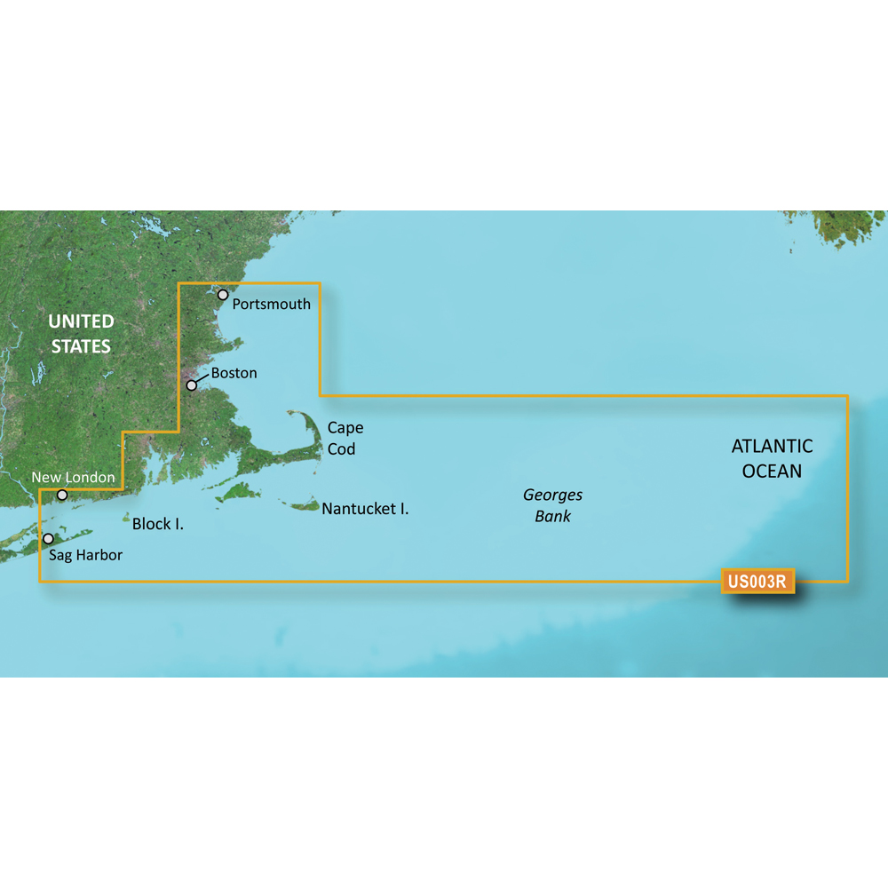
Garmin BlueChart g3 Vision HD - VUS003R - Cape Cod - microSD/SD
Garmin BlueChart g3 Vision HD - VUS003R - Cape Cod - microSD/SD
Online
$349.98for Each
Retail $349.99
Mfr PN: 010-C0704-00
Stock: 21
|
BlueChart® g3 Vision® HD - VUS003R - Cape Cod - microSD™/SD™ Coverage: Gloucester through New London, including Narragansett Bay, Block Island, Martha's Vineyard, Nantucket Island, the entire Cape, and includes general coverage Georges Bank. Premier Coastal Navigation Charts
Experience unparalleled coverage and brilliant detail on the water. BlueChart g3 Vision coastal charts provide industry-leading coverage, clarity and detail with integrated Garmin and Navionics data, Auto Guidance technology and high-resolution relief shading.. Auto Guidance Technology The Auto Guidance feature¹ uses your desired depth and overhead clearance to calculate a route and a suggested path to follow. High-resolution Relief Shading Feature High-resolution relief shading combines color and shadow to give you an easy-to-interpret, clearer view of bottom structure than contour lines alone. Up to 1’ Contours The closer the contour lines, the more accurate the depiction of the bottom structure for improved fishing charts and navigation in swamps, canals and marinas. NOAA Raster Cartography If you prefer your display to have the look of paper charts, NOAA raster cartography2 is available as a free downloadable feature via the ActiveCaptain® app. Depth Range Shading This feature provides up to 10 depth ranges, enabling you to view your target depth at a glance. Shallow Water Shading This feature allows you to use shading to designate the shallow water depths you need to avoid. High-resolution Satellite Imagery These detailed images of ports, marinas, bridges and navigational landmarks help provide you with superior situational awareness. Unique 3-D Views MarinerEye and FishEye views provide additional perspective both above and below the water line. ¹Auto Guidance is for planning purposes only and does not replace safe navigation operations
|
Online
$349.98for Each
Retail $349.99
Mfr PN: 010-C0704-00
Stock: 21

Garmin BlueChart g3 Vision HD - VUS004R - New York - microSD/SD
Garmin BlueChart g3 Vision HD - VUS004R - New York - microSD/SD
Online
$349.98for Each
Retail $349.99
Mfr PN: 010-C0705-00
Stock: 21
|
BlueChart® g3 Vision® HD - VUS004R - New York - microSD™/SD™ Coverage: Providence to New York, includes Narragansett Bay, all of Long Island, the entire Hudson River, New York Harbor through Perth Amboy and Brick Township Premier Coastal Navigation Charts
Experience unparalleled coverage and brilliant detail on the water. BlueChart g3 Vision coastal charts provide industry-leading coverage, clarity and detail with integrated Garmin and Navionics data, Auto Guidance technology and high-resolution relief shading.. Auto Guidance Technology The Auto Guidance feature¹ uses your desired depth and overhead clearance to calculate a route and a suggested path to follow. High-resolution Relief Shading Feature High-resolution relief shading combines color and shadow to give you an easy-to-interpret, clearer view of bottom structure than contour lines alone. Up to 1’ Contours The closer the contour lines, the more accurate the depiction of the bottom structure for improved fishing charts and navigation in swamps, canals and marinas. NOAA Raster Cartography If you prefer your display to have the look of paper charts, NOAA raster cartography2 is available as a free downloadable feature via the ActiveCaptain® app. Depth Range Shading This feature provides up to 10 depth ranges, enabling you to view your target depth at a glance. Shallow Water Shading This feature allows you to use shading to designate the shallow water depths you need to avoid. High-resolution Satellite Imagery These detailed images of ports, marinas, bridges and navigational landmarks help provide you with superior situational awareness. Unique 3-D Views MarinerEye and FishEye views provide additional perspective both above and below the water line. ¹Auto Guidance is for planning purposes only and does not replace safe navigation operations
|
Online
$349.98for Each
Retail $349.99
Mfr PN: 010-C0705-00
Stock: 21

Garmin BlueChart g3 Vision HD - VUS007R - Norfolk - Charleston - microSD/SD
Garmin BlueChart g3 Vision HD - VUS007R - Norfolk - Charleston - microSD/SD
Online
$349.98for Each
Retail $349.99
Mfr PN: 010-C0708-00
Stock: 21
|
BlueChart® g3 Vision® HD - VUS007R - Norfolk - Charleston - microSD™/SD™ Coverage: Newport News, VA to Charleston, SC including Pamlico Sound, Cape Lookout, and Cape Romain. Premier Coastal Navigation Charts
Experience unparalleled coverage and brilliant detail on the water. BlueChart g3 Vision coastal charts provide industry-leading coverage, clarity and detail with integrated Garmin and Navionics data, Auto Guidance technology and high-resolution relief shading.. Auto Guidance Technology The Auto Guidance feature¹ uses your desired depth and overhead clearance to calculate a route and a suggested path to follow. High-resolution Relief Shading Feature High-resolution relief shading combines color and shadow to give you an easy-to-interpret, clearer view of bottom structure than contour lines alone. Up to 1’ Contours The closer the contour lines, the more accurate the depiction of the bottom structure for improved fishing charts and navigation in swamps, canals and marinas. NOAA Raster Cartography If you prefer your display to have the look of paper charts, NOAA raster cartography2 is available as a free downloadable feature via the ActiveCaptain® app. Depth Range Shading This feature provides up to 10 depth ranges, enabling you to view your target depth at a glance. Shallow Water Shading This feature allows you to use shading to designate the shallow water depths you need to avoid. High-resolution Satellite Imagery These detailed images of ports, marinas, bridges and navigational landmarks help provide you with superior situational awareness. Unique 3-D Views MarinerEye and FishEye views provide additional perspective both above and below the water line. ¹Auto Guidance is for planning purposes only and does not replace safe navigation operations
|
Online
$349.98for Each
Retail $349.99
Mfr PN: 010-C0708-00
Stock: 21

Garmin BlueChart g3 Vision HD - VUS008R - Charleston to Jacksonville - microSD/SD
Garmin BlueChart g3 Vision HD - VUS008R - Charleston to Jacksonville - microSD/SD
Online
$349.98for Each
Retail $349.99
Mfr PN: 010-C0709-00
Stock: 21
|
BlueChart® g3 Vision® HD - VUS008R - Charleston to Jacksonville - microSD™/SD™ Coverage: Cape Romain through St. Augustine including Charleston, Savannah and Jacksonville with the St. John's River covered to the Clay County line. Premier Coastal Navigation Charts
Experience unparalleled coverage and brilliant detail on the water. BlueChart g3 Vision coastal charts provide industry-leading coverage, clarity and detail with integrated Garmin and Navionics data, Auto Guidance technology and high-resolution relief shading.. Auto Guidance Technology The Auto Guidance feature¹ uses your desired depth and overhead clearance to calculate a route and a suggested path to follow. High-resolution Relief Shading Feature High-resolution relief shading combines color and shadow to give you an easy-to-interpret, clearer view of bottom structure than contour lines alone. Up to 1’ Contours The closer the contour lines, the more accurate the depiction of the bottom structure for improved fishing charts and navigation in swamps, canals and marinas. NOAA Raster Cartography If you prefer your display to have the look of paper charts, NOAA raster cartography2 is available as a free downloadable feature via the ActiveCaptain® app. Depth Range Shading This feature provides up to 10 depth ranges, enabling you to view your target depth at a glance. Shallow Water Shading This feature allows you to use shading to designate the shallow water depths you need to avoid. High-resolution Satellite Imagery These detailed images of ports, marinas, bridges and navigational landmarks help provide you with superior situational awareness. Unique 3-D Views MarinerEye and FishEye views provide additional perspective both above and below the water line. ¹Auto Guidance is for planning purposes only and does not replace safe navigation operations
|
Online
$349.98for Each
Retail $349.99
Mfr PN: 010-C0709-00
Stock: 21

Garmin BlueChart g3 Vision HD - VUS009R - Jacksonville - Key West - microSD/SD
Garmin BlueChart g3 Vision HD - VUS009R - Jacksonville - Key West - microSD/SD
Online
$349.98for Each
Retail $349.99
Mfr PN: 010-C0710-00
Stock: 21
|
BlueChart® g3 Vision® HD - VUS009R - Jacksonville - Key West - microSD™/SD™ Coverage: Featuring data from the Explorer Charts of the Bahamas. Darien, GA to Key West, FL including the entire St. John's River, the St. Lucie Canal, Lake Okeechobee, with coverage over to Ft. Myers. Also includes detailed coverage of Bimini, the Abacos and Grand Bahama Island. Premier Coastal Navigation Charts
Experience unparalleled coverage and brilliant detail on the water. BlueChart g3 Vision coastal charts provide industry-leading coverage, clarity and detail with integrated Garmin and Navionics data, Auto Guidance technology and high-resolution relief shading.. Auto Guidance Technology The Auto Guidance feature¹ uses your desired depth and overhead clearance to calculate a route and a suggested path to follow. High-resolution Relief Shading Feature High-resolution relief shading combines color and shadow to give you an easy-to-interpret, clearer view of bottom structure than contour lines alone. Up to 1’ Contours The closer the contour lines, the more accurate the depiction of the bottom structure for improved fishing charts and navigation in swamps, canals and marinas. NOAA Raster Cartography If you prefer your display to have the look of paper charts, NOAA raster cartography2 is available as a free downloadable feature via the ActiveCaptain® app. Depth Range Shading This feature provides up to 10 depth ranges, enabling you to view your target depth at a glance. Shallow Water Shading This feature allows you to use shading to designate the shallow water depths you need to avoid. High-resolution Satellite Imagery These detailed images of ports, marinas, bridges and navigational landmarks help provide you with superior situational awareness. Unique 3-D Views MarinerEye and FishEye views provide additional perspective both above and below the water line. ¹Auto Guidance is for planning purposes only and does not replace safe navigation operations
|
Online
$349.98for Each
Retail $349.99
Mfr PN: 010-C0710-00
Stock: 21
|
|
|
|
Copyright © 1999-2024 BuilderDepot, Inc. Site Designed and Maintained by Inline Internet Systems, Inc. |