
Browse In:
Shop by Brand: Garmin
Sort by
Items 1-
32
of 640 total

Garmin BlueChart g2 HD - HXAE006R - Timor Leste/New Guinea - microSD/SD
Garmin BlueChart g2 HD - HXAE006R - Timor Leste/New Guinea - microSD/SD
Online
$159.98for Each
Retail $159.99
Mfr PN: 010-C0881-20
Stock: 0
|
BlueChart® g2 HD - HXAE006R - Timor Leste/New Guinea - microSD™/SD™ Coverage: Coasts of Timor Leste; the northernmost parts of Melville Island and the Cobourg Peninsula of Australia; Indonesia southeast and east of Sulawesi; Osprey Reef; all of Papua New Guinea and the Solomon Islands. Detailed coverage of Ambon, Indonesia; Snake Bay, Australia; Ternate, Indon, Lae, Rabaul, Karema and Port Moresby, P.N.G. and Honaira, S.I. Our Advanced Chart Offering
Advanced Chart Detail Detailed charts help the mariner guide their boat in and out of port with confidence. Depth Range Shading Displays high-resolution Depth Range Shading for up to 10 depth ranges so you can view your designated target depth. Detailed Contours BlueChart g2 HD features 1-foot contours that provide a more accurate depiction of bottom structure for improved fishing charts and enhanced detail in swamps, canals and port plans.
|
 WARNING: This product can expose you to chemicals which are known to the State of California to cause cancer, birth defects or other reproductive harm. For more information go to
 Online
$159.98for Each
Retail $159.99
Mfr PN: 010-C0881-20
Stock: 0

Garmin BlueChart g2 HD - HXAE009R - Singapore / Malaysia / Indonesia - microSD / SD
Garmin BlueChart g2 HD - HXAE009R - Singapore / Malaysia / Indonesia - microSD / SD
Online
$159.98for Each
Retail $159.99
Mfr PN: 010-C0884-20
Stock: 0
|
BlueChart® g2 HD - HXAE009R - Singapore / Malaysia / Indonesia - microSD™ / SD™ Coverage: Detailed coverage of the southwestern portion of the Malay Peninsula through Singapore and the eastern side of Sumatra Island. Also included are numerous detailed charts covering areas such as Kuantan, Mal., Jakarta, Indo., and Merak, Indo., as well as Christmas, Keeling, and Cocos Islands. General coverage of Java, Celebas, the southern half of Borneo and other surrounding islands east to Timor. Our Advanced Chart Offering
Advanced Chart Detail Detailed charts help the mariner guide their boat in and out of port with confidence. Depth Range Shading Displays high-resolution Depth Range Shading for up to 10 depth ranges so you can view your designated target depth. Detailed Contours BlueChart g2 HD features 1-foot contours that provide a more accurate depiction of bottom structure for improved fishing charts and enhanced detail in swamps, canals and port plans.
|
Online
$159.98for Each
Retail $159.99
Mfr PN: 010-C0884-20
Stock: 0

Garmin BlueChart g2 HD - HXAF001R - Eastern Africa - microSD/SD
Garmin BlueChart g2 HD - HXAF001R - Eastern Africa - microSD/SD
Online
$129.98for Each
Retail $129.99
Mfr PN: 010-C0747-20
Stock: 10
|
BlueChart® g2 HD - HXAF001R - Eastern Africa - microSD™/SD™ Coverage: General coverage of the east coast of Africa from the Gulf of Tadjoura to the Bay of Maputo, including Mogadishu, Som., Mombasa, Ken., and Dar es Salaam, Tan. Also includes general coverage of the entire coast of Madagascar. Includes detailed coverage of Djibouti, Dji., Maputo, Moz., Mauritius, Reunion, and the Seychelles. Our Advanced Chart Offering
Advanced Chart Detail Detailed charts help the mariner guide their boat in and out of port with confidence. Depth Range Shading Displays high-resolution Depth Range Shading for up to 10 depth ranges so you can view your designated target depth. Detailed Contours BlueChart g2 HD features 1-foot contours that provide a more accurate depiction of bottom structure for improved fishing charts and enhanced detail in swamps, canals and port plans.
|
Online
$129.98for Each
Retail $129.99
Mfr PN: 010-C0747-20
Stock: 10

Garmin BlueChart g2 HD - HXAF002R - South Africa - microSD/SD
Garmin BlueChart g2 HD - HXAF002R - South Africa - microSD/SD
Online
$129.98for Each
Retail $129.99
Mfr PN: 010-C0748-20
Stock: 10
|
BlueChart® g2 HD - HXAF002R - South Africa - microSD™/SD™ Coverage: Detailed coverage of the coast of southern Africa from Namibe, Ang. to Angoche, Moz., including the South African cities of Cape Town and Port Elizabeth. Includes detailed coverage of Durban S. Af. and Maputo, Moz. Also includes detailed coverage of the Tristan da Cunha Group, the island of St. Helena, and the Prince Edward Islands. Our Advanced Chart Offering
Advanced Chart Detail Detailed charts help the mariner guide their boat in and out of port with confidence. Depth Range Shading Displays high-resolution Depth Range Shading for up to 10 depth ranges so you can view your designated target depth. Detailed Contours BlueChart g2 HD features 1-foot contours that provide a more accurate depiction of bottom structure for improved fishing charts and enhanced detail in swamps, canals and port plans.
|
Online
$129.98for Each
Retail $129.99
Mfr PN: 010-C0748-20
Stock: 10

Garmin BlueChart g2 HD - HXAF003R - Western Africa - microSD/SD
Garmin BlueChart g2 HD - HXAF003R - Western Africa - microSD/SD
Online
$129.98for Each
Retail $129.99
Mfr PN: 010-C0749-20
Stock: 10
|
BlueChart® g2 HD - HXAF003R - Western Africa Coverage: General coverage of the west coast of Africa from El Aaraich, Mor. to Cape Cross, Nam., including Abidjan, C.I., Douala, Cam. and Luanda, Ang. Included in this overall general coverage are a number of detailed charts covering areas such as Casablanca, Mor., Dakar, Sen., and Lagos, Nig. Also includes general coverage of St. Helena Is., Ascension Is., and the Azores. Also includes detailed coverage of the Madeira Islands, Canary Islands, and Cape Verde Islands. Our Advanced Chart Offering
Advanced Chart Detail Detailed charts help the mariner guide their boat in and out of port with confidence. Depth Range Shading Displays high-resolution Depth Range Shading for up to 10 depth ranges so you can view your designated target depth. Detailed Contours BlueChart g2 HD features 1-foot contours that provide a more accurate depiction of bottom structure for improved fishing charts and enhanced detail in swamps, canals and port plans.
|
Online
$129.98for Each
Retail $129.99
Mfr PN: 010-C0749-20
Stock: 10

Garmin BlueChart g2 HD - HXAW003R - Indian Subcontinent - microSD/SD
Garmin BlueChart g2 HD - HXAW003R - Indian Subcontinent - microSD/SD
Online
$129.98for Each
Retail $129.99
Mfr PN: 010-C0755-20
Stock: 10
|
BlueChart® g2 HD - HXAW003R - Indian Subcontinent - microSD™/SD™ Coverage: General coverage of the Indian subcontinent from Pasni, Pak., to Sandoway, Myan. Included in this overall general coverage are a number of detailed charts covering areas such as the Indian cities of Mangalore, Quilon, and Calcutta. Also includes general coverage of Sri Lanka, the Andaman and Nicobar Islands, the Chagos Archipelago, and the Maldives, except for the detailed coverage of the Male Atoll. Our Advanced Chart Offering
Advanced Chart Detail Detailed charts help the mariner guide their boat in and out of port with confidence. Depth Range Shading Displays high-resolution Depth Range Shading for up to 10 depth ranges so you can view your designated target depth. Detailed Contours BlueChart g2 HD features 1-foot contours that provide a more accurate depiction of bottom structure for improved fishing charts and enhanced detail in swamps, canals and port plans.
|
Online
$129.98for Each
Retail $129.99
Mfr PN: 010-C0755-20
Stock: 10

Garmin BlueChart g2 HD - HXEU065R - Baltic Sea East Coast - microSD/SD
Garmin BlueChart g2 HD - HXEU065R - Baltic Sea East Coast - microSD/SD
Online
$129.98for Each
Retail $129.99
Mfr PN: 010-C0849-20
Stock: 10
|
BlueChart® g2 HD - HXEU065R - Baltic Sea East Coast - microSD™/SD™ Coverage: Coverage of the coasts of the Estonia, Latvia, Lithuania, Russia, and Poland from Narva-Joesuu, Est. to Rugen, Ger. Includes Gotland, Bornholm, Gulf of Riga, Kaliningrad, Rus., and the Polish cities of Gdansk, Gdynia, and Szczecin. Unparalleled Coastal Chart Coverage
BlueChart g3 coastal charts provide industry-leading coverage, clarity and detail with integrated Garmin and Navionics data. Also included is Auto Guidance1 technology, which uses your desired depth and overhead clearance to calculate routes and provide a suggested path to follow — overlaid onto your chart. NOAA raster cartography is also available as a free downloadable feature via the ActiveCaptain app. It gives your chartplotter paper chartlike views of NOAA-surveyed areas in which individual points of interest are labeled with corresponding longitude and latitude information. Worldwide coverage is available by regions as accessory cards or via download; each region is sold separately. Auto Guidance Technology The Auto Guidance feature¹ calculates a suggested route using your desired depth and overhead clearance. Depth Range Shading This feature displays high-resolution Depth Range Shading for up to 10 depth ranges so you can view your designated target depth. Detailed Contours BlueChart g3 charts feature 1’ contours that provide a more accurate depiction of bottom structure for improved fishing charts and enhanced detail in swamps, canals and port plans. Shallow Water Shading To aid in navigation, Shallow Water Shading allows map shading at a user-defined depth to give a clear picture of shallow waters to avoid. NOAA Raster Cartography This feature gives your chartplotter paper chartlike views of NOAA-surveyed areas in which points of interest are labeled with corresponding longitude and latitude information. ¹Auto Guidance is for planning purposes only and does not replace safe navigation practices. Auto Guidance is not included in preloaded BlueChart g3 for ECHOMAP™ Plus series chartplotters
|
Online
$129.98for Each
Retail $129.99
Mfr PN: 010-C0849-20
Stock: 10

Garmin BlueChart g2 HD - HXPC018R - New Caledonia To Fiji - microSD/SD
Garmin BlueChart g2 HD - HXPC018R - New Caledonia To Fiji - microSD/SD
Online
$159.98for Each
Retail $159.99
Mfr PN: 010-C0865-20
Stock: 0
|
BlueChart® g2 HD - HXPC018R - New Caledonia to Fiji - microSD™/SD™ Coverage: Detailed coverage of New Caledonia including Port de Pouebo, and Baie de Yate, as well as the isles of Ouvea, Lifo, and Mare. General coverage of the southeastern Solomon Islands including Guadalcanal, San Cristobal, and the southern portion of Malaita. General coverage continues among the Santa Cruz Island, Vanuatu, Fiji, Tonga, Samoa, and American Samoa, including numerous detailed plans such as Port-Vila, Van., Suva, Fij., Nuku'alofa, Ton., Apia, Sam., and Pago Pago, Am. Sam. Our Advanced Chart Offering
Advanced Chart Detail Detailed charts help the mariner guide their boat in and out of port with confidence. Depth Range Shading Displays high-resolution Depth Range Shading for up to 10 depth ranges so you can view your designated target depth. Detailed Contours BlueChart g2 HD features 1-foot contours that provide a more accurate depiction of bottom structure for improved fishing charts and enhanced detail in swamps, canals and port plans.
|
Online
$159.98for Each
Retail $159.99
Mfr PN: 010-C0865-20
Stock: 0

Garmin BlueChart g2 HD - HXPC019R - Polynesia - microSD/SD
Garmin BlueChart g2 HD - HXPC019R - Polynesia - microSD/SD
Online
$159.98for Each
Retail $159.99
Mfr PN: 010-C0866-20
Stock: 0
|
BlueChart® g2 HD - HXPC019R - Polynesia - microSD™/SD™ Coverage: General coverage of the coasts of Tonga, Samoa, American Samoa, French Polynesia, Kiribati, and the Cook Islands. Included in this overall general coverage are numerous detailed charts covering areas such as Nuku'alofa, Ton., Apia, Sam., Pago Pago, Am. Sam., Tahiti, and Bora Bora. Our Advanced Chart Offering
Advanced Chart Detail Detailed charts help the mariner guide their boat in and out of port with confidence. Depth Range Shading Displays high-resolution Depth Range Shading for up to 10 depth ranges so you can view your designated target depth. Detailed Contours BlueChart g2 HD features 1-foot contours that provide a more accurate depiction of bottom structure for improved fishing charts and enhanced detail in swamps, canals and port plans.
|
Online
$159.98for Each
Retail $159.99
Mfr PN: 010-C0866-20
Stock: 0

Garmin BlueChart g2 HD - HXPC024R - Australia & New Zealand - microSD/SD
Garmin BlueChart g2 HD - HXPC024R - Australia & New Zealand - microSD/SD
Online
$159.98for Each
Retail $159.99
Mfr PN: 010-C1020-20
Stock: 0
|
BlueChart® g2 HD - HXPC024R - Australia & New Zealand - microSD™/SD™ Coverage: The entire continent of Australia and New Zealand. Coverage includes Brisbane, Sydney, and the Great Barrier Reef along the Eastern coast. Coverage continues along the Southern coast including Melbourne, Adelaide, and Tasmania through the Great Australian Bight. Coverage also includes Perth, Geraldton, Darwin, and the Gulf of Carpentaria on the Western and Northern coasts. Detailed coverage of New Zealand, including the North and South Islands in their entirety, as well as Norfolk Island, Auckland Islands, Campbell Island, Antipodes Islands, and Bounty Islands. Our Advanced Chart Offering
Advanced Chart Detail Detailed charts help the mariner guide their boat in and out of port with confidence. Depth Range Shading Displays high-resolution Depth Range Shading for up to 10 depth ranges so you can view your designated target depth. Detailed Contours BlueChart g2 HD features 1-foot contours that provide a more accurate depiction of bottom structure for improved fishing charts and enhanced detail in swamps, canals and port plans.
|
Online
$159.98for Each
Retail $159.99
Mfr PN: 010-C1020-20
Stock: 0

Garmin BlueChart g2 HD - HXPC410S - Esperance To Exmouth Bay - microSD/SD
Garmin BlueChart g2 HD - HXPC410S - Esperance To Exmouth Bay - microSD/SD
Online
$84.98for Each
Retail $84.99
Mfr PN: 010-C0868-20
Stock: 0
|
BlueChart® g2 HD - HXPC410S - Esperance to Exmouth Bay - microSD™/SD™ Coverage: Detailed coverage of the Southwest coast of Australia from Esperance to Dorre Island and Exmouth Bay. Detailed coverage of Geraldton, Perth, and Bunbury also included. Our Advanced Chart Offering
Advanced Chart Detail Detailed charts help the mariner guide their boat in and out of port with confidence. Depth Range Shading Displays high-resolution Depth Range Shading for up to 10 depth ranges so you can view your designated target depth. Detailed Contours BlueChart g2 HD features 1-foot contours that provide a more accurate depiction of bottom structure for improved fishing charts and enhanced detail in swamps, canals and port plans.
|
Online
$84.98for Each
Retail $84.99
Mfr PN: 010-C0868-20
Stock: 0

Garmin BlueChart g2 HD - HXPC411S - Geraldton To Darwin - microSD/SD
Garmin BlueChart g2 HD - HXPC411S - Geraldton To Darwin - microSD/SD
Online
$84.98for Each
Retail $84.99
Mfr PN: 010-C0869-20
Stock: 0
|
BlueChart® g2 HD - HXPC411S - Geraldton to Darwin - microSD™/SD™ Coverage: Detailed coverage of the Northwest coast of Australia from Geraldton to Darwin. Also includes detailed coverage of Carnarvon, Port Hedland, Broome, Joseph Bonaparte Gulf, as well as Melville and Bathurst Islands. Our Advanced Chart Offering
Advanced Chart Detail Detailed charts help the mariner guide their boat in and out of port with confidence. Depth Range Shading Displays high-resolution Depth Range Shading for up to 10 depth ranges so you can view your designated target depth. Detailed Contours BlueChart g2 HD features 1-foot contours that provide a more accurate depiction of bottom structure for improved fishing charts and enhanced detail in swamps, canals and port plans.
|
Online
$84.98for Each
Retail $84.99
Mfr PN: 010-C0869-20
Stock: 0

Garmin BlueChart g2 HD - HXPC412S - Admiralty Gulf Wa To Cairns - microSD/SD
Garmin BlueChart g2 HD - HXPC412S - Admiralty Gulf Wa To Cairns - microSD/SD
Online
$84.98for Each
Retail $84.99
Mfr PN: 010-C0870-20
Stock: 0
|
BlueChart® g2 HD - HXPC412S - Admiralty Gulf to Cairns - microSD®/SD® Coverage: Detailed coverage of Northern Australia from Admiralty Gulf to Cairns. Also includes detailed coverage of Joseph Bonaparte Gulf, Darwin, Wessel Islands, Gulf of Carpentaria, Cape York, and the Great Barrier Reef. Our Advanced Chart Offering
Advanced Chart Detail Detailed charts help the mariner guide their boat in and out of port with confidence. Depth Range Shading Displays high-resolution Depth Range Shading for up to 10 depth ranges so you can view your designated target depth. Detailed Contours BlueChart g2 HD features 1-foot contours that provide a more accurate depiction of bottom structure for improved fishing charts and enhanced detail in swamps, canals and port plans.
|
Online
$84.98for Each
Retail $84.99
Mfr PN: 010-C0870-20
Stock: 0

Garmin BlueChart g2 HD - HXPC413S - Mornington Island - Hervey Bay - microSD/SD
Garmin BlueChart g2 HD - HXPC413S - Mornington Island - Hervey Bay - microSD/SD
Online
$84.98for Each
Retail $84.99
Mfr PN: 010-C0871-20
Stock: 0
|
BlueChart® g2 HD - HXPC413S - Mornington Island - Hervey Bay - microSD™/SD™ Coverage: Detailed coverage of the Northeastern coast of Australia from Mornington Island to Hervey Bay. Also includes detailed coverage of Cape York, Cairns, Townsville, Mackay, and the Great Barrier Reef. Our Advanced Chart Offering
Advanced Chart Detail Detailed charts help the mariner guide their boat in and out of port with confidence. Depth Range Shading Displays high-resolution Depth Range Shading for up to 10 depth ranges so you can view your designated target depth. Detailed Contours BlueChart g2 HD features 1-foot contours that provide a more accurate depiction of bottom structure for improved fishing charts and enhanced detail in swamps, canals and port plans.
|
Online
$84.98for Each
Retail $84.99
Mfr PN: 010-C0871-20
Stock: 0

Garmin BlueChart g2 HD - HXPC414S - Mackay - Twofold Bay - microSD/SD
Garmin BlueChart g2 HD - HXPC414S - Mackay - Twofold Bay - microSD/SD
Online
$84.98for Each
Retail $84.99
Mfr PN: 010-C0872-20
Stock: 0
|
BlueChart® g2 HD - HXPC414S - Mackay - Twofold Bay - microSD™/SD™ Coverage: Detailed coverage of the Eastern coast of Australia from Mackay to Eden. Also includes detailed coverage of Hervey Bay, Fraser Island, Brisbane, Port Stephens, and Sydney. Our Advanced Chart Offering
Advanced Chart Detail Detailed charts help the mariner guide their boat in and out of port with confidence. Depth Range Shading Displays high-resolution Depth Range Shading for up to 10 depth ranges so you can view your designated target depth. Detailed Contours BlueChart g2 HD features 1-foot contours that provide a more accurate depiction of bottom structure for improved fishing charts and enhanced detail in swamps, canals and port plans.
|
Online
$84.98for Each
Retail $84.99
Mfr PN: 010-C0872-20
Stock: 0

Garmin BlueChart g2 HD - HXPC415S - Port Stephens - Fowlers Bay - microSD/SD
Garmin BlueChart g2 HD - HXPC415S - Port Stephens - Fowlers Bay - microSD/SD
Online
$84.98for Each
Retail $84.99
Mfr PN: 010-C0873-20
Stock: 0
|
BlueChart® g2 HD - HXPC415S - Port Stephens - Fowlers Bay - microSD™/SD™ Coverage: Detailed coverage of the Southeastern coast of Australia from Port Stephens to Fowlers Bay. Also includes detailed coverage of Sydney, Flinders and King Islands, Tasmania, Melbourne, and Adelaide. Our Advanced Chart Offering
Advanced Chart Detail Detailed charts help the mariner guide their boat in and out of port with confidence. Depth Range Shading Displays high-resolution Depth Range Shading for up to 10 depth ranges so you can view your designated target depth. Detailed Contours BlueChart g2 HD features 1-foot contours that provide a more accurate depiction of bottom structure for improved fishing charts and enhanced detail in swamps, canals and port plans.
|
Online
$84.98for Each
Retail $84.99
Mfr PN: 010-C0873-20
Stock: 0

Garmin BlueChart g2 HD - HXPC416S - New Zealand North - microSD/SD
Garmin BlueChart g2 HD - HXPC416S - New Zealand North - microSD/SD
Online
$84.98for Each
Retail $84.99
Mfr PN: 010-C0874-20
Stock: 0
|
BlueChart® g2 HD - HPC416S - New Zealand North - microSD™/SD™ Coverage: Includes the entire coast of the North Island, including the Three Kings Islands; also includes the northernmost part of the South Island, from Cape Foulwind to Cape Campbell, including Nelson. Our Advanced Chart Offering
Advanced Chart Detail Detailed charts help the mariner guide their boat in and out of port with confidence. Depth Range Shading Displays high-resolution Depth Range Shading for up to 10 depth ranges so you can view your designated target depth. Detailed Contours BlueChart g2 HD features 1-foot contours that provide a more accurate depiction of bottom structure for improved fishing charts and enhanced detail in swamps, canals and port plans.
|
Online
$84.98for Each
Retail $84.99
Mfr PN: 010-C0874-20
Stock: 0

Garmin BlueChart g2 HD - HXPC417S - New Zealand South - microSD/SD
Garmin BlueChart g2 HD - HXPC417S - New Zealand South - microSD/SD
Online
$84.98for Each
Retail $84.99
Mfr PN: 010-C0875-20
Stock: 0
|
BlueChart® g2 HD - HXPC417S - New Zealand South - microSD®/SD™ Coverage: Includes the entire coast of the South Island, including the Bounty Islands to the southeast and Snares islands to the southwest; also includes the southernmost part of the North Island, from Foxton Beach to Cape Turnagain, including Wellington. Our Advanced Chart Offering
Advanced Chart Detail Detailed charts help the mariner guide their boat in and out of port with confidence. Depth Range Shading Displays high-resolution Depth Range Shading for up to 10 depth ranges so you can view your designated target depth. Detailed Contours BlueChart g2 HD features 1-foot contours that provide a more accurate depiction of bottom structure for improved fishing charts and enhanced detail in swamps, canals and port plans.
|
Online
$84.98for Each
Retail $84.99
Mfr PN: 010-C0875-20
Stock: 0

Garmin BlueChart g2 HD - HXSA600X - South America - microSD/SD
Garmin BlueChart g2 HD - HXSA600X - South America - microSD/SD
Online
$219.98for Each
Retail $219.99
Mfr PN: 010-C1067-20
Stock: 15
|
BlueChart® g2 HD - HXSA600X - South America - microSD™/SD™ Coverage: Detailed coverage of the entire South American continent including the Amazon River; Lake Titicaca; Trinidad and Tobago; the Galapagos, San Felix, Juan Fernández and Falkland Islands (Las Malvinas). Coverage also includes the Panama Canal Zone; the Caribbean coast of Central America to Bluefields, NI; the Islas de San Andrés and the Pacific coast of Central America to Las Islas Revillagigedo, MX. Our Advanced Chart Offering
Advanced Chart Detail Detailed charts help the mariner guide their boat in and out of port with confidence. Depth Range Shading Displays high-resolution Depth Range Shading for up to 10 depth ranges so you can view your designated target depth. Detailed Contours BlueChart g2 HD features 1-foot contours that provide a more accurate depiction of bottom structure for improved fishing charts and enhanced detail in swamps, canals and port plans.
|
Online
$219.98for Each
Retail $219.99
Mfr PN: 010-C1067-20
Stock: 15

Garmin BlueChart g2 HD - HXUS021R - California - Mexico - microSD/SD
Garmin BlueChart g2 HD - HXUS021R - California - Mexico - microSD/SD
Online
$149.98for Each
Retail $149.99
Mfr PN: 010-C0722-20
Stock: 33
|
BlueChart® g2 HD - HXUS021R - California - Mexico - microSD™/SD™ Coverage: Point Arena to Puerto Vallarta, including Mendocino, San Francisco Bay, Channel Islands, San Diego, and the Baja Peninsula. General coverage for the Mexican coast, including Mazatlan, Acapulco and Salina Cruz. Our Advanced Chart Offering
Advanced Chart Detail Detailed charts help the mariner guide their boat in and out of port with confidence. Depth Range Shading Displays high-resolution Depth Range Shading for up to 10 depth ranges so you can view your designated target depth. Detailed Contours BlueChart g2 HD features 1-foot contours that provide a more accurate depiction of bottom structure for improved fishing charts and enhanced detail in swamps, canals and port plans.
|
Online
$149.98for Each
Retail $149.99
Mfr PN: 010-C0722-20
Stock: 33

Garmin BlueChart g2 HD - HXUS030R - Southeast Caribbean - microSD/SD
Garmin BlueChart g2 HD - HXUS030R - Southeast Caribbean - microSD/SD
Online
$149.98for Each
Retail $149.99
Mfr PN: 010-C0731-20
Stock: 33
|
BlueChart® g2 HD - HXUS030R - Southeast Caribbean - microSD™/SD™ Coverage: Covers the Caribbean from Haiti to Trinidad & Tobago, including Puerto Rico and all of the Lesser Antilles. Also includes the Colombian and Venezuelan coasts from Barranquilla, Colombia to the mouth of the Orinoco River, including Lake Maracaibo and the Gulf of Paria. Our Advanced Chart Offering
Advanced Chart Detail Detailed charts help the mariner guide their boat in and out of port with confidence. Depth Range Shading Displays high-resolution Depth Range Shading for up to 10 depth ranges so you can view your designated target depth. Detailed Contours BlueChart g2 HD features 1-foot contours that provide a more accurate depiction of bottom structure for improved fishing charts and enhanced detail in swamps, canals and port plans.
|
Online
$149.98for Each
Retail $149.99
Mfr PN: 010-C0731-20
Stock: 33
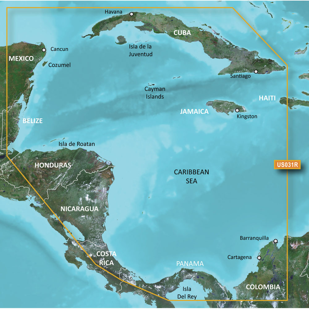
Garmin BlueChart g2 HD - HXUS031R - Southwest Caribbean - microSD/SD
Garmin BlueChart g2 HD - HXUS031R - Southwest Caribbean - microSD/SD
Online
$149.98for Each
Retail $149.99
Mfr PN: 010-C0732-20
Stock: 33
|
BlueChart® g2 HD - HXUS031R - Southwest Caribbean - microSD™/SD™ Coverage: Detailed coverage of the northern coast of Central America from Cancun, Mexico to Barranquilla, Colombia, including the Panama Canal in its entirety. General coverage of the northern half of the Gulf of Panama. Also includes detailed coverage of the coasts of Cuba, Jamaica, and the Caymans in their entirety. Our Advanced Chart Offering
Advanced Chart Detail Detailed charts help the mariner guide their boat in and out of port with confidence. Depth Range Shading Displays high-resolution Depth Range Shading for up to 10 depth ranges so you can view your designated target depth. Detailed Contours BlueChart g2 HD features 1-foot contours that provide a more accurate depiction of bottom structure for improved fishing charts and enhanced detail in swamps, canals and port plans.
|
Online
$149.98for Each
Retail $149.99
Mfr PN: 010-C0732-20
Stock: 33

Garmin BlueChart g2 Vision HD - VAF003R - Western Africa - microSD/SD
Garmin BlueChart g2 Vision HD - VAF003R - Western Africa - microSD/SD
Online
$249.98for Each
Retail $249.99
Mfr PN: 010-C0749-00
Stock: 0
|
BlueChart® g2 Vision® HD - VAF003R - Western Africa - microSD™/SD™ Coverage: The west coast of Africa from El Aaraich, Mor. to Cape Cross, Nam., including Abidjan, C.I., Douala, Cam. and Luanda, Ang. Included in this overall general coverage are a number of detailed charts covering areas such as Casablanca, Mor., Dakar, Sen., and Lagos, Nig. Also includes general coverage of St. Helena Is., Ascension Is., and the Azores. Also includes detailed coverage of the Madeira Islands, Canary Islands, and Cape Verde Islands. Our Premium Chart Offering
Auto Guidance¹ Auto Guidance technology quickly calculates a suggested route using your boat's dimensions and a suggested path to follow. Depth Range Shading Displays high-resolution Depth Range Shading for up to 10 depth ranges so you can view your designated target depth. Detailed Contours BlueChart g2 Vision HD features 1-foot contours that provide a more accurate depiction of bottom structure for improved fishing charts and enhanced detail in swamps, canals and port plans. MarinerEye View Provides a 3-D representation of the ocean floor as seen from below the waterline. FishEye View Provides a 3-D representation of the surrounding area both above and below the waterline. Aerial Photography Crystal clear aerial photography shows exceptional detail of many ports, harbors and marinas and is ideal when entering unfamiliar ports. ¹Auto Guidance is for planning purposes only and does not replace safe navigation practices
|
Online
$249.98for Each
Retail $249.99
Mfr PN: 010-C0749-00
Stock: 0

Garmin BlueChart g2 Vision HD - VAF450S - Madeira & Canary Islands - microSD/SD
Garmin BlueChart g2 Vision HD - VAF450S - Madeira & Canary Islands - microSD/SD
Online
$174.97for Each
Retail $174.99
Mfr PN: 010-C0750-00
Stock: 0
|
BlueChart® g2 Vision® HD - VAF450S - Madeira & Canary Islands - microSD™/SD™ Coverage: The Arquiplago da Madeira and the Canary Islands with detailed port plans including Arrecife, Puerto del Rosario, and Canial. Includes general coverage of the southwestern coast of Morocco from Marruecos, Mor. to El Aauin in Western Sahara. Our Premium Chart Offering
Auto Guidance¹ Auto Guidance technology quickly calculates a suggested route using your boat's dimensions and a suggested path to follow. Depth Range Shading Displays high-resolution Depth Range Shading for up to 10 depth ranges so you can view your designated target depth. Detailed Contours BlueChart g2 Vision HD features 1-foot contours that provide a more accurate depiction of bottom structure for improved fishing charts and enhanced detail in swamps, canals and port plans. MarinerEye View Provides a 3-D representation of the ocean floor as seen from below the waterline. FishEye View Provides a 3-D representation of the surrounding area both above and below the waterline. High-resolution Satellite Imagery High-resolution satellite imagery with navigational charts overlaid gives you a realistic view of your surroundings so you can navigate with a clear moving-chart representation of your boat’s position. It’s our most realistic charting display in a chartplotter. Aerial Photography Crystal clear aerial photography shows exceptional detail of many ports, harbors and marinas and is ideal when entering unfamiliar ports. ¹Auto Guidance is for planning purposes only and does not replace safe navigation practices
|
Online
$174.97for Each
Retail $174.99
Mfr PN: 010-C0750-00
Stock: 0

Garmin BlueChart g2 Vision HD - VAF451S - Namibia - Knysna, SA - microSD/SD
Garmin BlueChart g2 Vision HD - VAF451S - Namibia - Knysna, SA - microSD/SD
Online
$174.97for Each
Retail $174.99
Mfr PN: 010-C0751-00
Stock: 0
|
Bluechart® g2 Vision® HD - VAF451S - Namibia - Knysna, SA - microSD™/SD™ Coverage: The southwestern coast of Africa from Cape Ponta-Grossa in Angola through Knysa, S. Af. Including detailed coverage of Walvis Bay, Nam., as well as Port Nolloth, Hondelklipbaais, and Cape Town, S. Af. Detailed coverage also includes the island of St. Helena, the Tristan da Cunha Group, and Gough Island. Our Premium Chart Offering
Auto Guidance¹ Auto Guidance technology quickly calculates a suggested route using your boat's dimensions and a suggested path to follow. Depth Range Shading Displays high-resolution Depth Range Shading for up to 10 depth ranges so you can view your designated target depth. Detailed Contours BlueChart g2 Vision HD features 1-foot contours that provide a more accurate depiction of bottom structure for improved fishing charts and enhanced detail in swamps, canals and port plans. MarinerEye View Provides a 3-D representation of the ocean floor as seen from below the waterline. FishEye View Provides a 3-D representation of the surrounding area both above and below the waterline. High-resolution Satellite Imagery High-resolution satellite imagery with navigational charts overlaid gives you a realistic view of your surroundings so you can navigate with a clear moving-chart representation of your boat’s position. It’s our most realistic charting display in a chartplotter. Aerial Photography Crystal clear aerial photography shows exceptional detail of many ports, harbors and marinas and is ideal when entering unfamiliar ports. ¹Auto Guidance is for planning purposes only and does not replace safe navigation practices
|
Online
$174.97for Each
Retail $174.99
Mfr PN: 010-C0751-00
Stock: 0

Garmin BlueChart g2 Vision HD - VAF452S - Knysna, SA to Beira, MZ - microSD/SD
Garmin BlueChart g2 Vision HD - VAF452S - Knysna, SA to Beira, MZ - microSD/SD
Online
$174.97for Each
Retail $174.99
Mfr PN: 010-C0752-00
Stock: 0
|
BlueChart® g2 Vision® HD - VAF452S - Knysna, SA to Beira, MZ - microSD™/SD™ Coverage: The southeastern coast of Africa from Mossel Bay, S. Af. to the mouth of the Zambezi River. Detailed coverage includes Port Elizabeth and Durban, S. Af., Maputo, Moz., as well as the Prince Edward Islands. Our Premium Chart Offering
Auto Guidance¹ Auto Guidance technology quickly calculates a suggested route using your boat's dimensions and a suggested path to follow. Depth Range Shading Displays high-resolution Depth Range Shading for up to 10 depth ranges so you can view your designated target depth. Detailed Contours BlueChart g2 Vision HD features 1-foot contours that provide a more accurate depiction of bottom structure for improved fishing charts and enhanced detail in swamps, canals and port plans. MarinerEye View Provides a 3-D representation of the ocean floor as seen from below the waterline. FishEye View Provides a 3-D representation of the surrounding area both above and below the waterline. High-resolution Satellite Imagery High-resolution satellite imagery with navigational charts overlaid gives you a realistic view of your surroundings so you can navigate with a clear moving-chart representation of your boat’s position. It’s our most realistic charting display in a chartplotter. Aerial Photography Crystal clear aerial photography shows exceptional detail of many ports, harbors and marinas and is ideal when entering unfamiliar ports. ¹Auto Guidance is for planning purposes only and does not replace safe navigation practices
|
Online
$174.97for Each
Retail $174.99
Mfr PN: 010-C0752-00
Stock: 0

Garmin BlueChart g2 Vision HD - VAW450S - The Gulf - microSD/SD
Garmin BlueChart g2 Vision HD - VAW450S - The Gulf - microSD/SD
Online
$174.97for Each
Retail $174.99
Mfr PN: 010-C0758-00
Stock: 2
|
BlueChart® g2 Vision® HD - VAW450S - The Gulf - microSD™/SD™ Coverage: Kuwait, Saudi Arabia, Qatar, United Arab Emirates, along the southern coast of the Gulf, including Al-Fuhaihil, Ad-Dammam, Bahrain, Ad-Dauha, and Abu Dhabi. Coverage of Iran along the northern coast of the Gulf including Bushehr and Bandar-e Abbas. Coverage of the Strait of Hormuz and the Gulf of Oman. General coverage of the Arabian Sea from Qamar Bay to the Delta of the Indus River. Our Premium Chart Offering
Auto Guidance¹ Auto Guidance technology quickly calculates a suggested route using your boat's dimensions and a suggested path to follow. Depth Range Shading Displays high-resolution Depth Range Shading for up to 10 depth ranges so you can view your designated target depth. Detailed Contours BlueChart g2 Vision HD features 1-foot contours that provide a more accurate depiction of bottom structure for improved fishing charts and enhanced detail in swamps, canals and port plans. MarinerEye View Provides a 3-D representation of the ocean floor as seen from below the waterline. FishEye View Provides a 3-D representation of the surrounding area both above and below the waterline. High-resolution Satellite Imagery High-resolution satellite imagery with navigational charts overlaid gives you a realistic view of your surroundings so you can navigate with a clear moving-chart representation of your boat’s position. It’s our most realistic charting display in a chartplotter. Aerial Photography Crystal clear aerial photography shows exceptional detail of many ports, harbors and marinas and is ideal when entering unfamiliar ports.
|
Online
$174.97for Each
Retail $174.99
Mfr PN: 010-C0758-00
Stock: 2

Garmin BlueChart g2 Vision HD - VAW451S - Red Sea - microSD/SD
Garmin BlueChart g2 Vision HD - VAW451S - Red Sea - microSD/SD
Online
$174.97for Each
Retail $174.99
Mfr PN: 010-C0759-00
Stock: 0
|
BlueChart® g2 Vision® HD - VAW451S - Red Sea - microSD™/SD™ Coverage: The Red Sea and Gulf of Aden in their entirety, as well as the Indian Ocean including portions of the coasts of Somalia and Oman. Also includes coverage of the Mediterranean Sea from Beirut, Leb. to Alexandria Egy., including the Suez Canal and Gulf of Aqaba. Included in this overall general coverage are numerous detailed charts covering areas such as Jiddah, Sau., Djibouti, Dji., and Aden, Yem. Our Premium Chart Offering
Auto Guidance¹ Auto Guidance technology quickly calculates a suggested route using your boat's dimensions and a suggested path to follow. Depth Range Shading Displays high-resolution Depth Range Shading for up to 10 depth ranges so you can view your designated target depth. Detailed Contours BlueChart g2 Vision HD features 1-foot contours that provide a more accurate depiction of bottom structure for improved fishing charts and enhanced detail in swamps, canals and port plans. MarinerEye View Provides a 3-D representation of the ocean floor as seen from below the waterline. FishEye View Provides a 3-D representation of the surrounding area both above and below the waterline. High-resolution Satellite Imagery High-resolution satellite imagery with navigational charts overlaid gives you a realistic view of your surroundings so you can navigate with a clear moving-chart representation of your boat’s position. It’s our most realistic charting display in a chartplotter. Aerial Photography Crystal clear aerial photography shows exceptional detail of many ports, harbors and marinas and is ideal when entering unfamiliar ports. ¹Auto Guidance is for planning purposes only and does not replace safe navigation practices
|
Online
$174.97for Each
Retail $174.99
Mfr PN: 010-C0759-00
Stock: 0

Garmin BlueChart g2 Vision HD - VUS021R - California-Mexico - microSD/SD
Garmin BlueChart g2 Vision HD - VUS021R - California-Mexico - microSD/SD
Online
$349.98for Each
Retail $349.99
Mfr PN: 010-C0722-00
Stock: 21
|
BlueChart® g2 Vision® HD - VUS021R - California - Mexico - microSD™/SD™ Coverage: Point Arena to Puerto Vallarta, including Mendocino, San Francisco Bay, Channel Islands, San Diego, and the Baja Peninsula. General coverage for the Mexican coast, including Mazatlan, Acapulco and Salina Cruz. Our Premium Chart Offering
Auto Guidance¹ Auto Guidance technology quickly calculates a suggested route using your boat's dimensions and a suggested path to follow. Depth Range Shading Displays high-resolution Depth Range Shading for up to 10 depth ranges so you can view your designated target depth. Detailed Contours BlueChart g2 Vision HD features 1-foot contours that provide a more accurate depiction of bottom structure for improved fishing charts and enhanced detail in swamps, canals and port plans. MarinerEye View Provides a 3-D representation of the ocean floor as seen from below the waterline. FishEye View Provides a 3-D representation of the surrounding area both above and below the waterline. High-resolution Satellite Imagery High-resolution satellite imagery with navigational charts overlaid gives you a realistic view of your surroundings so you can navigate with a clear moving-chart representation of your boat’s position. It’s our most realistic charting display in a chartplotter. Aerial Photography Crystal clear aerial photography shows exceptional detail of many ports, harbors and marinas and is ideal when entering unfamiliar ports. ¹Auto Guidance is for planning purposes only and does not replace safe navigation operations
|
Online
$349.98for Each
Retail $349.99
Mfr PN: 010-C0722-00
Stock: 21

Garmin BlueChart g2 Vision HD - VUS030R - Southeast Caribbean - microSD/SD
Garmin BlueChart g2 Vision HD - VUS030R - Southeast Caribbean - microSD/SD
Online
$349.98for Each
Retail $349.99
Mfr PN: 010-C0731-00
Stock: 21
|
BlueChart® g2 Vision® HD - VUS030R - Southeast Caribbean - microSD™/SD™ Coverage: Covers the Caribbean from Haiti to Trinidad & Tobago, including Puerto Rico and all of the Lesser Antilles. Also includes the Colombian and Venezuelan coasts from Barranquilla, Colombia to the mouth of the Orinoco River, including Lake Maracaibo and the Gulf of Paria. Our Premium Chart Offering
Auto Guidance¹ Auto Guidance technology quickly calculates a suggested route using your boat's dimensions and a suggested path to follow. Depth Range Shading Displays high-resolution Depth Range Shading for up to 10 depth ranges so you can view your designated target depth. Detailed Contours BlueChart g2 Vision HD features 1-foot contours that provide a more accurate depiction of bottom structure for improved fishing charts and enhanced detail in swamps, canals and port plans. MarinerEye View Provides a 3-D representation of the ocean floor as seen from below the waterline. FishEye View Provides a 3-D representation of the surrounding area both above and below the waterline. High-resolution Satellite Imagery High-resolution satellite imagery with navigational charts overlaid gives you a realistic view of your surroundings so you can navigate with a clear moving-chart representation of your boat’s position. It’s our most realistic charting display in a chartplotter. Aerial Photography Crystal clear aerial photography shows exceptional detail of many ports, harbors and marinas and is ideal when entering unfamiliar ports. ¹Auto Guidance is for planning purposes only and does not replace safe navigation operations
|
Online
$349.98for Each
Retail $349.99
Mfr PN: 010-C0731-00
Stock: 21

Garmin BlueChart g2 Vision HD - VUS031R - Southwest Caribbean - microSD/SD
Garmin BlueChart g2 Vision HD - VUS031R - Southwest Caribbean - microSD/SD
Online
$349.98for Each
Retail $349.99
Mfr PN: 010-C0732-00
Stock: 21
|
BlueChart® g2 Vision® HD - VUS031R - Southwest Caribbean - microSD™/SD™ Coverage: Detailed coverage of the northern coast of Central America from Cancun, Mexico to Barranquilla, Colombia, including the Panama Canal in its entirety. General coverage of the northern half of the Gulf of Panama. Also includes detailed coverage of the coasts of Cuba, Jamaica, and the Caymans in their entirety. Our Premium Chart Offering
Auto Guidance¹ Auto Guidance technology quickly calculates a suggested route using your boat's dimensions and a suggested path to follow. Depth Range Shading Displays high-resolution Depth Range Shading for up to 10 depth ranges so you can view your designated target depth. Detailed Contours BlueChart g2 Vision HD features 1-foot contours that provide a more accurate depiction of bottom structure for improved fishing charts and enhanced detail in swamps, canals and port plans. MarinerEye View Provides a 3-D representation of the ocean floor as seen from below the waterline. FishEye View Provides a 3-D representation of the surrounding area both above and below the waterline. High-resolution Satellite Imagery High-resolution satellite imagery with navigational charts overlaid gives you a realistic view of your surroundings so you can navigate with a clear moving-chart representation of your boat’s position. It’s our most realistic charting display in a chartplotter. Aerial Photography Crystal clear aerial photography shows exceptional detail of many ports, harbors and marinas and is ideal when entering unfamiliar ports. ¹Auto Guidance is for planning purposes only and does not replace safe navigation operations
|
Online
$349.98for Each
Retail $349.99
Mfr PN: 010-C0732-00
Stock: 21

Garmin BlueChart g2 Vision HD - VUS032R - Southern Gulf of Mexico - microSD/SD
Garmin BlueChart g2 Vision HD - VUS032R - Southern Gulf of Mexico - microSD/SD
Online
$349.98for Each
Retail $349.99
Mfr PN: 010-C0733-00
Stock: 21
|
BlueChart® g2 Vision® HD - VUS032R - Southern Gulf of Mexico - microSD™/SD™ Coverage: Covers the Gulf of Mexico from Matagorda Bay to Belize City, including Corpus Christi, TX, Veracruz, Mex., the Bay of Campeche, Cancun, Mex., and Cozumel, Mex. Our Premium Chart Offering
Auto Guidance¹ Auto Guidance technology quickly calculates a suggested route using your boat's dimensions and a suggested path to follow. Depth Range Shading Displays high-resolution Depth Range Shading for up to 10 depth ranges so you can view your designated target depth. Detailed Contours BlueChart g2 Vision HD features 1-foot contours that provide a more accurate depiction of bottom structure for improved fishing charts and enhanced detail in swamps, canals and port plans. MarinerEye View Provides a 3-D representation of the ocean floor as seen from below the waterline. FishEye View Provides a 3-D representation of the surrounding area both above and below the waterline. High-resolution Satellite Imagery High-resolution satellite imagery with navigational charts overlaid gives you a realistic view of your surroundings so you can navigate with a clear moving-chart representation of your boat’s position. It’s our most realistic charting display in a chartplotter. Aerial Photography Crystal clear aerial photography shows exceptional detail of many ports, harbors and marinas and is ideal when entering unfamiliar ports. ¹Auto Guidance is for planning purposes only and does not replace safe navigation operations
|
Online
$349.98for Each
Retail $349.99
Mfr PN: 010-C0733-00
Stock: 21
|
|
|
|
Copyright © 1999-2024 BuilderDepot, Inc. Site Designed and Maintained by Inline Internet Systems, Inc. |